Molobulahe geodata
Molobulahe (Gorontalo) is a seat of a third-order administrative division; located in Indonesia in Asia/Makassar (GMT+8) time zone. In our database, there are 407 cities with bigger population. Compared to other cities in Indonesia, 95.7% of cities are located further ↓South; 89.1% of cities are located further ←West and 71.2% of cities have higher elevation than Molobulahe. Note1


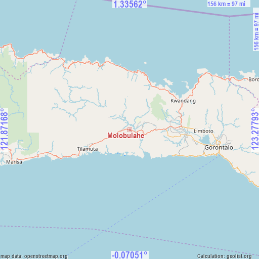
Molobulahe GPS coordinates[2]
0° 37' 57.36" North, 122° 34' 29.28" East
| Map corner | latitude | longitude |
|---|---|---|
| Upper-left | 1.33562°, | 121.87168° |
| Center: | 0.6326°, | 122.5748° |
| Lower-right: | -0.07051°, | 123.27793° |
| Map W x H: | 156.3×156.4 km | = 97.1×97.2mi |
| max Lat: | 5.88969° ⇑4.3% North |
| Molobulahe: | 0.6326° |
| min Lat: | ⇓95.7% South -10.934° |
| min Long | Molobulahe | max Long |
| 95.1345° | 122.5748° | 140.9419° |
| W 89.1%⇐ | ⇒10.9% E |
Elevation
Elevation of Molobulahe is 30 m = 98 ft, and this is 199.7 m = 655 ft below average elevation for this country.
| Max E: |
3185 m = 10449 ft | 71.2% |
| Avg. | 229.7 m = 754 ft | |
| Molobulahe | 30 m = 98 ft | |
Min E: |
-1 m = -3 ft | 28.8% |
See also: Indonesia elevation on elevation.city.
Geographical zone
Molobulahe is located in North Torrid zone (between Equator and Tropic of Cancer). Distance of Equator is 70.3 km =43.7 mi to South.| Distance of | km | miles | from Molobulahe |
|---|---|---|---|
| North Pole | 9936.7 | 6174.4 | to North |
| Arctic Circle | 7330.8 | 4555.1 | to North |
| Tropic Cancer | 2535.6 | 1575.5 | to North |
| Equator | 70.3 | 43.7 | to South |


Nearby cities:
15 places around Molobulahe: (largest is in red/bold)
• Bilungala
76.3 km =47.4 mi,  111°
111°
• Bolangitang
86.9 km =54 mi,  69°
69°
• Boroko
82.9 km =51.5 mi, 68°
• Bunobogu
116.2 km =72.2 mi,  292°
292°
• Gorontalo
55.2 km =34.3 mi,  101°
101°
• Isimu
31.9 km =19.8 mi,  87°
87°
• Kwandang
44 km =27.3 mi,  59°
59°
• Lemito
112 km =69.6 mi,  264°
264°
• Limboto
44.8 km =27.8 mi, 90°
• Marisa
73.1 km =45.4 mi, 255°
• Payunga
42.6 km =26.5 mi, 100°
• Pimpi
111.9 km =69.5 mi,  75°
75°
• Sidomulyo
4.9 km =3 mi, 67°
• Suwawa
64.6 km =40.1 mi, 99°
• Tilamuta
28 km =17.4 mi,  245°
245°
Sources, notices
• [Note1] Compared only with cities in Indonesia existing in our database
• [Src1] Map data: © OpenStreetMap contributors (CC-BY-SA)
• [Src2] Other city data from geonames.org with taken over terms of usage.
• [Src3] Geographical zone / Annual Mean Temperature by Robert A. Rohde @ Wikipedia
