Babat geodata
Babat (East Java) is a populated place; located in Indonesia in Asia/Jakarta (GMT+7) time zone. With population of 27,038 people, there are 339 cities with bigger population in this country. Compared to other cities in Indonesia, 59.4% of cities are located further ↓South; 51.3% of cities are located further ←West and 87.7% of cities have higher elevation than Babat. Note1


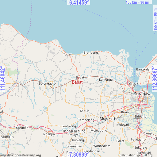
Babat GPS coordinates[2]
7° 6' 46.152" South, 112° 9' 48.744" East
| Map corner | latitude | longitude |
|---|---|---|
| Upper-left | -6.41459°, | 111.46042° |
| Center: | -7.11282°, | 112.16354° |
| Lower-right: | -7.80999°, | 112.86667° |
| Map W x H: | 155.2×155.2 km | = 96.4×96.4mi |
| max Lat: | 5.88969° ⇑40.6% North |
| Babat: | -7.11282° |
| min Lat: | ⇓59.4% South -10.934° |
| min Long | Babat | max Long |
| 95.1345° | 112.16354° | 140.9419° |
| W 51.3%⇐ | ⇒48.7% E |
Elevation
Elevation of Babat is 12 m = 39 ft, and this is 217.7 m = 714 ft below average elevation for this country.
| Max E: |
3185 m = 10449 ft | 87.7% |
| Avg. | 229.7 m = 754 ft | |
| Babat | 12 m = 39 ft | |
Min E: |
-1 m = -3 ft | 12.3% |
See also: Indonesia elevation on elevation.city.
Geographical zone
Babat is located in South Torrid zone (between Equator and Tropic of Capricorn). Distance of Equator is 790.9 km =491.4 mi to North.| Distance of | km | miles | from Babat |
|---|---|---|---|
| Equator | 790.9 | 491.4 | to North |
| Tropic Capricorn | 1815 | 1127.8 | to South |
| Antarctic Circle | 6610.3 | 4107.4 | to South |
| South Pole | 9216.2 | 5726.7 | to South |


Nearby cities:
15 places around Babat: (largest is in red/bold)
• Dateng
16.9 km =10.5 mi,  26°
26°
• Dempel
13.6 km =8.5 mi,  335°
335°
• Drudikrajan
18.8 km =11.7 mi,  323°
323°
• Gelap
17.4 km =10.8 mi, 28°
• Gesing
17.5 km =10.9 mi, 340°
• Jabung
14.9 km =9.3 mi, 29°
• Jangkungkusumo
19.3 km =12 mi,  43°
43°
• Krajan Dermawuharjo
19 km =11.8 mi,  308°
308°
• Kujung
14.5 km =9 mi,  15°
15°
• Maduran
17.7 km =11 mi,  46°
46°
• Mlangi
12.9 km =8 mi,  9°
9°
• Ngimbang
16.7 km =10.4 mi,  352°
352°
• Nginokrajan
17.2 km =10.7 mi, 320°
• Pelangwot
19.1 km =11.9 mi, 42°
• Sumberjo
12.8 km =8 mi,  1°
1°
Sources, notices
• [Note1] Compared only with cities in Indonesia existing in our database
• [Src1] Map data: © OpenStreetMap contributors (CC-BY-SA)
• [Src2] Other city data from geonames.org with taken over terms of usage.
• [Src3] Geographical zone / Annual Mean Temperature by Robert A. Rohde @ Wikipedia
