Wicklow geodata
Wicklow (Leinster) is a seat of a second-order administrative division; located in Ireland in Europe/Dublin (GMT+1) time zone. With population of 14,048 people, there are 36 cities with bigger population in this country. Compared to other cities in Ireland, 62.2% of cities are located further ↑North; 100% of cities are located further ←West and 51.6% of cities have lower elevation than Wicklow. Note1


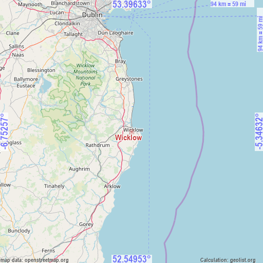
Wicklow GPS coordinates[2]
52° 58' 30" North, 6° 2' 57.984" West
| Map corner | latitude | longitude |
|---|---|---|
| Upper-left | 53.39633°, | -6.75257° |
| Center: | 52.975°, | -6.04944° |
| Lower-right: | 52.54953°, | -5.34632° |
| Map W x H: | 94.2×94.2 km | = 58.5×58.5mi |
| max Lat: | 55.25° ⇑62.2% North |
| Wicklow: | 52.975° |
| min Lat: | ⇓37.8% South 51.52487° |
| min Long | Wicklow | max Long |
| -10.26889° | -6.04944° | -6.04944° |
| W 100%⇐ | ⇒0% E |
Elevation
Elevation of Wicklow is 53 m = 174 ft, and this is 1.5 m = 5 ft below average elevation for this country.
| Max E: |
262 m = 860 ft | 48.4% |
| Avg. | 54.5 m = 179 ft | |
| Wicklow | 53 m = 174 ft | |
Min E: |
0 m = 0 ft | 51.6% |
See also: Ireland elevation on elevation.city.
Geographical zone
Wicklow is located in North temperate zone (between Tropic of Cancer and the Arctic Circle). Distance of this North polar circle is 1510.9 km =938.8 mi to North.| Distance of | km | miles | from Wicklow |
|---|---|---|---|
| North Pole | 4116.8 | 2558.1 | to North |
| Arctic Circle | 1510.9 | 938.8 | to North |
| Tropic Cancer | 3284.3 | 2040.8 | to South |
| Equator | 5890.3 | 3660.1 | to South |


Nearby cities:
15 places around Wicklow: (largest is in red/bold)
• Arklow
21.1 km =13.1 mi,  196°
196°
• Ashford
5.6 km =3.5 mi,  311°
311°
• Avoca
17.6 km =10.9 mi,  219°
219°
• Charlesland
17 km =10.6 mi,  356°
356°
• Glenealy
7.4 km =4.6 mi,  258°
258°
• Greystones
18.5 km =11.5 mi, 357°
• Kilcoole
14.2 km =8.8 mi, 355°
• Kilmacanoge
22.1 km =13.7 mi,  345°
345°
• Kilpedder
15.4 km =9.6 mi, 345°
• Kilquade
13.8 km =8.6 mi, 350°
• Newcastle
10.4 km =6.5 mi, 353°
• Newtownmountkennedy
13.5 km =8.4 mi,  342°
342°
• Rathdrum
13.6 km =8.5 mi,  246°
246°
• Rathnew
3 km =1.9 mi, 305°
• Roundwood
15 km =9.3 mi, 308°
Sources, notices
• [Note1] Compared only with cities in Ireland existing in our database
• [Src1] Map data: © OpenStreetMap contributors (CC-BY-SA)
• [Src2] Other city data from geonames.org with taken over terms of usage.
• [Src3] Geographical zone / Annual Mean Temperature by Robert A. Rohde @ Wikipedia
