Kilcoole geodata
Kilcoole (Leinster) is a populated place; located in Ireland in Europe/Dublin (GMT+1) time zone. With population of 4,049 people, there are 155 cities with bigger population in this country. Compared to other cities in Ireland, 58.1% of cities are located further ↑North; 99.4% of cities are located further ←West and 78.4% of cities have higher elevation than Kilcoole. Note1


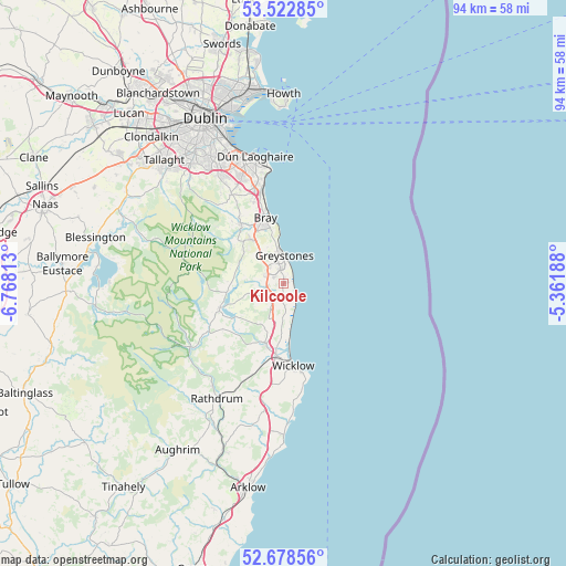
Kilcoole GPS coordinates[2]
53° 6' 10.008" North, 6° 3' 54" West
| Map corner | latitude | longitude |
|---|---|---|
| Upper-left | 53.52285°, | -6.76813° |
| Center: | 53.10278°, | -6.065° |
| Lower-right: | 52.67856°, | -5.36188° |
| Map W x H: | 93.9×93.9 km | = 58.3×58.3mi |
| max Lat: | 55.25° ⇑58.1% North |
| Kilcoole: | 53.10278° |
| min Lat: | ⇓41.9% South 51.52487° |
| min Long | Kilcoole | max Long |
| -10.26889° | -6.065° | -6.04944° |
| W 99.4%⇐ | ⇒0.59999999999999% E |
Elevation
Elevation of Kilcoole is 18 m = 59 ft, and this is 36.5 m = 120 ft below average elevation for this country.
| Max E: |
262 m = 860 ft | 78.4% |
| Avg. | 54.5 m = 179 ft | |
| Kilcoole | 18 m = 59 ft | |
Min E: |
0 m = 0 ft | 21.6% |
See also: Ireland elevation on elevation.city.
Geographical zone
Kilcoole is located in North temperate zone (between Tropic of Cancer and the Arctic Circle). Distance of this North polar circle is 1496.7 km =930 mi to North.| Distance of | km | miles | from Kilcoole |
|---|---|---|---|
| North Pole | 4102.6 | 2549.2 | to North |
| Arctic Circle | 1496.7 | 930 | to North |
| Tropic Cancer | 3298.6 | 2049.7 | to South |
| Equator | 5904.5 | 3668.9 | to South |


Nearby cities:
15 places around Kilcoole: (largest is in red/bold)
• Ashford
10.9 km =6.8 mi,  196°
196°
• Bray
11.3 km =7 mi,  348°
348°
• Charlesland
2.8 km =1.7 mi,  2°
2°
• Enniskerry
12.2 km =7.6 mi,  325°
325°
• Greystones
4.2 km =2.6 mi, 1°
• Kilmacanoge
8.5 km =5.3 mi, 327°
• Kilpedder
2.9 km =1.8 mi,  284°
284°
• Kilquade
1.4 km =0.9 mi,  245°
245°
• Little Bray
11.9 km =7.4 mi,  341°
341°
• Newcastle
3.8 km =2.4 mi,  180°
180°
• Newtownmountkennedy
3.4 km =2.1 mi, 246°
• Rathnew
12.6 km =7.8 mi,  186°
186°
• Roundwood
11.8 km =7.3 mi, 245°
• Shankill
14.3 km =8.9 mi, 343°
• Wicklow
14.2 km =8.8 mi, 175°
Sources, notices
• [Note1] Compared only with cities in Ireland existing in our database
• [Src1] Map data: © OpenStreetMap contributors (CC-BY-SA)
• [Src2] Other city data from geonames.org with taken over terms of usage.
• [Src3] Geographical zone / Annual Mean Temperature by Robert A. Rohde @ Wikipedia
