Rathnew geodata
Rathnew (Leinster) is a populated place; located in Ireland in Europe/Dublin (GMT+1) time zone. With population of 2,964 people, there are 188 cities with bigger population in this country. Compared to other cities in Ireland, 61.7% of cities are located further ↑North; 98.5% of cities are located further ←West and 67.4% of cities have higher elevation than Rathnew. Note1


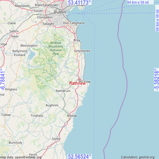
Rathnew GPS coordinates[2]
52° 59' 26.016" North, 6° 5' 7.008" West
| Map corner | latitude | longitude |
|---|---|---|
| Upper-left | 53.41173°, | -6.78841° |
| Center: | 52.99056°, | -6.08528° |
| Lower-right: | 52.56524°, | -5.38216° |
| Map W x H: | 94.1×94.1 km | = 58.5×58.5mi |
| max Lat: | 55.25° ⇑61.7% North |
| Rathnew: | 52.99056° |
| min Lat: | ⇓38.3% South 51.52487° |
| min Long | Rathnew | max Long |
| -10.26889° | -6.08528° | -6.04944° |
| W 98.5%⇐ | ⇒1.5% E |
Elevation
Elevation of Rathnew is 28 m = 92 ft, and this is 26.5 m = 87 ft below average elevation for this country.
| Max E: |
262 m = 860 ft | 67.4% |
| Avg. | 54.5 m = 179 ft | |
| Rathnew | 28 m = 92 ft | |
Min E: |
0 m = 0 ft | 32.6% |
See also: Ireland elevation on elevation.city.
Geographical zone
Rathnew is located in North temperate zone (between Tropic of Cancer and the Arctic Circle). Distance of this North polar circle is 1509.2 km =937.8 mi to North.| Distance of | km | miles | from Rathnew |
|---|---|---|---|
| North Pole | 4115.1 | 2557 | to North |
| Arctic Circle | 1509.2 | 937.8 | to North |
| Tropic Cancer | 3286.1 | 2041.9 | to South |
| Equator | 5892 | 3661.1 | to South |


Nearby cities:
15 places around Rathnew: (largest is in red/bold)
• Arklow
22.3 km =13.9 mi,  189°
189°
• Ashford
2.6 km =1.6 mi,  318°
318°
• Avoca
17.7 km =11 mi,  209°
209°
• Charlesland
15.3 km =9.5 mi,  5°
5°
• Glenealy
5.8 km =3.6 mi,  236°
236°
• Greystones
16.8 km =10.4 mi, 5°
• Kilcoole
12.6 km =7.8 mi, 6°
• Kilmacanoge
19.9 km =12.4 mi,  350°
350°
• Kilpedder
13.3 km =8.3 mi, 353°
• Kilquade
11.9 km =7.4 mi,  0°
0°
• Newcastle
8.7 km =5.4 mi, 8°
• Newtownmountkennedy
11.3 km =7 mi, 351°
• Rathdrum
12.3 km =7.6 mi,  234°
234°
• Roundwood
12.1 km =7.5 mi,  308°
308°
• Wicklow
3 km =1.9 mi,  125°
125°
Sources, notices
• [Note1] Compared only with cities in Ireland existing in our database
• [Src1] Map data: © OpenStreetMap contributors (CC-BY-SA)
• [Src2] Other city data from geonames.org with taken over terms of usage.
• [Src3] Geographical zone / Annual Mean Temperature by Robert A. Rohde @ Wikipedia
