Rathdrum geodata
Rathdrum (Leinster) is a populated place; located in Ireland in Europe/Dublin (GMT+1) time zone. With population of 1,586 people, there are 259 cities with bigger population in this country. Compared to other cities in Ireland, 63.9% of cities are located further ↑North; 88% of cities are located further ←West and 97% of cities have lower elevation than Rathdrum. Note1


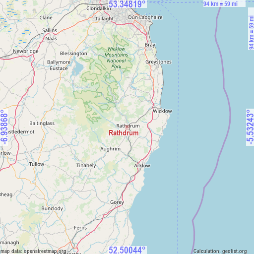
Rathdrum GPS coordinates[2]
52° 55' 35.004" North, 6° 14' 8.016" West
| Map corner | latitude | longitude |
|---|---|---|
| Upper-left | 53.34819°, | -6.93868° |
| Center: | 52.92639°, | -6.23556° |
| Lower-right: | 52.50044°, | -5.53243° |
| Map W x H: | 94.3×94.3 km | = 58.6×58.6mi |
| max Lat: | 55.25° ⇑63.9% North |
| Rathdrum: | 52.92639° |
| min Lat: | ⇓36.1% South 51.52487° |
| min Long | Rathdrum | max Long |
| -10.26889° | -6.23556° | -6.04944° |
| W 88%⇐ | ⇒12% E |
Elevation
Elevation of Rathdrum is 145 m = 476 ft, and this is 90.5 m = 297 ft above average elevation for this country.
| Max E: |
262 m = 860 ft | 3% |
| Rathdrum | 145 m 476 ft | |
| Avg. | 54.5 m = 179 ft | |
Min E: |
0 m = 0 ft | 97% |
See also: Ireland elevation on elevation.city.
Geographical zone
Rathdrum is located in North temperate zone (between Tropic of Cancer and the Arctic Circle). Distance of this North polar circle is 1516.3 km =942.2 mi to North.| Distance of | km | miles | from Rathdrum |
|---|---|---|---|
| North Pole | 4122.2 | 2561.4 | to North |
| Arctic Circle | 1516.3 | 942.2 | to North |
| Tropic Cancer | 3278.9 | 2037.4 | to South |
| Equator | 5884.9 | 3656.7 | to South |


Nearby cities:
15 places around Rathdrum: (largest is in red/bold)
• Arklow
16.1 km =10 mi,  156°
156°
• Ashford
12.3 km =7.6 mi,  42°
42°
• Aughrim
10.2 km =6.3 mi,  217°
217°
• Avoca
8.3 km =5.2 mi,  171°
171°
• Glenealy
6.5 km =4 mi,  53°
53°
• Hacketstown
22.6 km =14 mi,  252°
252°
• Kilpedder
22.1 km =13.7 mi,  22°
22°
• Kilquade
21.5 km =13.4 mi,  28°
28°
• Mucklagh
16.5 km =10.3 mi, 220°
• Newcastle
19.4 km =12.1 mi, 35°
• Newtownmountkennedy
20 km =12.4 mi, 24°
• Rathnew
12.3 km =7.6 mi, 54°
• Roundwood
14.7 km =9.1 mi,  2°
2°
• Tinahely
21 km =13 mi,  226°
226°
• Wicklow
13.6 km =8.5 mi,  66°
66°
Sources, notices
• [Note1] Compared only with cities in Ireland existing in our database
• [Src1] Map data: © OpenStreetMap contributors (CC-BY-SA)
• [Src2] Other city data from geonames.org with taken over terms of usage.
• [Src3] Geographical zone / Annual Mean Temperature by Robert A. Rohde @ Wikipedia
