Glenealy geodata
Glenealy (Leinster) is a populated place; located in Ireland in Europe/Dublin (GMT+1) time zone. With population of 670 people, there are 444 cities with bigger population in this country. Compared to other cities in Ireland, 62.4% of cities are located further ↑North; 94.1% of cities are located further ←West and 72.3% of cities have lower elevation than Glenealy. Note1


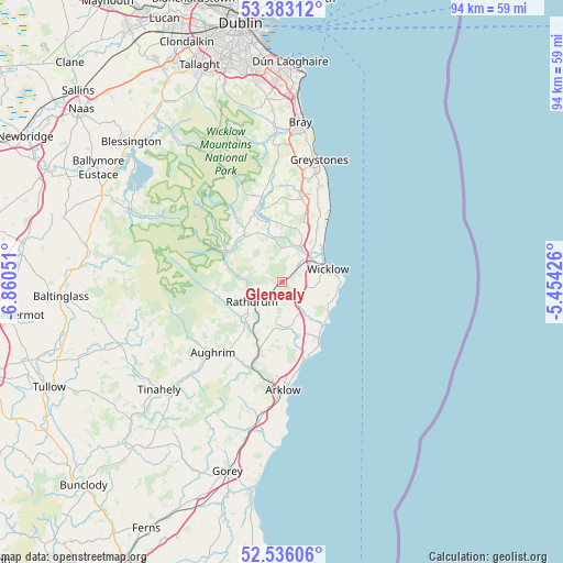
Glenealy GPS coordinates[2]
52° 57' 41.976" North, 6° 9' 26.604" West
| Map corner | latitude | longitude |
|---|---|---|
| Upper-left | 53.38312°, | -6.86051° |
| Center: | 52.96166°, | -6.15739° |
| Lower-right: | 52.53606°, | -5.45426° |
| Map W x H: | 94.2×94.2 km | = 58.5×58.5mi |
| max Lat: | 55.25° ⇑62.4% North |
| Glenealy: | 52.96166° |
| min Lat: | ⇓37.6% South 51.52487° |
| min Long | Glenealy | max Long |
| -10.26889° | -6.15739° | -6.04944° |
| W 94.1%⇐ | ⇒5.9% E |
Elevation
Elevation of Glenealy is 76 m = 249 ft, and this is 21.5 m = 71 ft above average elevation for this country.
| Max E: |
262 m = 860 ft | 27.7% |
| Glenealy | 76 m 249 ft | |
| Avg. | 54.5 m = 179 ft | |
Min E: |
0 m = 0 ft | 72.3% |
See also: Ireland elevation on elevation.city.
Geographical zone
Glenealy is located in North temperate zone (between Tropic of Cancer and the Arctic Circle). Distance of this North polar circle is 1512.4 km =939.8 mi to North.| Distance of | km | miles | from Glenealy |
|---|---|---|---|
| North Pole | 4118.3 | 2559 | to North |
| Arctic Circle | 1512.4 | 939.8 | to North |
| Tropic Cancer | 3282.9 | 2039.9 | to South |
| Equator | 5888.8 | 3659.1 | to South |


Nearby cities:
15 places around Glenealy: (largest is in red/bold)
• Arklow
18.8 km =11.7 mi,  176°
176°
• Ashford
6 km =3.7 mi,  30°
30°
• Aughrim
16.6 km =10.3 mi,  223°
223°
• Avoca
12.7 km =7.9 mi,  198°
198°
• Charlesland
19.5 km =12.1 mi,  18°
18°
• Greystones
20.9 km =13 mi, 17°
• Kilcoole
16.9 km =10.5 mi, 21°
• Kilpedder
16.7 km =10.4 mi,  11°
11°
• Kilquade
15.9 km =9.9 mi, 17°
• Newcastle
13.3 km =8.3 mi, 27°
• Newtownmountkennedy
14.7 km =9.1 mi, 12°
• Rathdrum
6.5 km =4 mi,  233°
233°
• Rathnew
5.8 km =3.6 mi,  56°
56°
• Roundwood
11.7 km =7.3 mi,  336°
336°
• Wicklow
7.4 km =4.6 mi,  78°
78°
Sources, notices
• [Note1] Compared only with cities in Ireland existing in our database
• [Src1] Map data: © OpenStreetMap contributors (CC-BY-SA)
• [Src2] Other city data from geonames.org with taken over terms of usage.
• [Src3] Geographical zone / Annual Mean Temperature by Robert A. Rohde @ Wikipedia
