Whitegate geodata
Whitegate (Munster) is a populated place; located in Ireland in Europe/Dublin (GMT+1) time zone. With population of 1,067 people, there are 336 cities with bigger population in this country. Compared to other cities in Ireland, 96.4% of cities are located further ↑North; 67.2% of cities are located further →East and 55.8% of cities have higher elevation than Whitegate. Note1


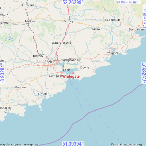
Whitegate GPS coordinates[2]
51° 49' 50.016" North, 8° 13' 46.992" West
| Map corner | latitude | longitude |
|---|---|---|
| Upper-left | 52.26299°, | -8.93284° |
| Center: | 51.83056°, | -8.22972° |
| Lower-right: | 51.39394°, | -7.52659° |
| Map W x H: | 96.6×96.6 km | = 60×60mi |
| max Lat: | 55.25° ⇑96.4% North |
| Whitegate: | 51.83056° |
| min Lat: | ⇓3.6% South 51.52487° |
| min Long | Whitegate | max Long |
| -10.26889° | -8.22972° | -6.04944° |
| W 32.8%⇐ | ⇒67.2% E |
Elevation
Elevation of Whitegate is 42 m = 138 ft, and this is 12.5 m = 41 ft below average elevation for this country.
| Max E: |
262 m = 860 ft | 55.8% |
| Avg. | 54.5 m = 179 ft | |
| Whitegate | 42 m = 138 ft | |
Min E: |
0 m = 0 ft | 44.2% |
See also: Ireland elevation on elevation.city.
Geographical zone
Whitegate is located in North temperate zone (between Tropic of Cancer and the Arctic Circle). Distance of this North polar circle is 1638.2 km =1017.9 mi to North.| Distance of | km | miles | from Whitegate |
|---|---|---|---|
| North Pole | 4244 | 2637.1 | to North |
| Arctic Circle | 1638.2 | 1017.9 | to North |
| Tropic Cancer | 3157.1 | 1961.7 | to South |
| Equator | 5763 | 3581 | to South |


Nearby cities:
15 places around Whitegate: (largest is in red/bold)
• Aghada
1.5 km =0.9 mi,  51°
51°
• Ballygarvan
16 km =9.9 mi,  266°
266°
• Belgooly
20.6 km =12.8 mi,  240°
240°
• Carrigaline
11.8 km =7.3 mi,  259°
259°
• Carrigtwohill
8.9 km =5.5 mi,  345°
345°
• Castlemartyr
15 km =9.3 mi, 53°
• Cloyne
8.1 km =5 mi,  63°
63°
• Cobh
5 km =3.1 mi,  296°
296°
• Cork
18.2 km =11.3 mi,  294°
294°
• Crosshaven
6.1 km =3.8 mi,  233°
233°
• Fountainstown
7.1 km =4.4 mi,  223°
223°
• Killeagh
20.2 km =12.6 mi, 52°
• Midleton
10 km =6.2 mi,  19°
19°
• Passage West
9.2 km =5.7 mi, 301°
• Riverstick
19.3 km =12 mi,  250°
250°
Sources, notices
• [Note1] Compared only with cities in Ireland existing in our database
• [Src1] Map data: © OpenStreetMap contributors (CC-BY-SA)
• [Src2] Other city data from geonames.org with taken over terms of usage.
• [Src3] Geographical zone / Annual Mean Temperature by Robert A. Rohde @ Wikipedia
