Cloyne geodata
Cloyne (Munster) is a populated place; located in Ireland in Europe/Dublin (GMT+1) time zone. With population of 1,562 people, there are 263 cities with bigger population in this country. Compared to other cities in Ireland, 95.4% of cities are located further ↑North; 64.7% of cities are located further →East and 73.8% of cities have higher elevation than Cloyne. Note1


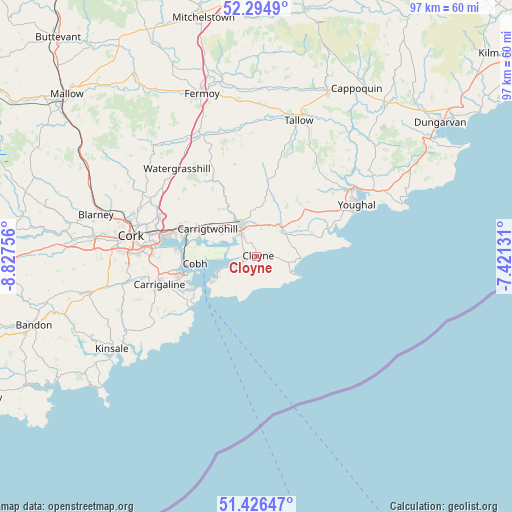
Cloyne GPS coordinates[2]
51° 51' 46.008" North, 8° 7' 27.984" West
| Map corner | latitude | longitude |
|---|---|---|
| Upper-left | 52.2949°, | -8.82756° |
| Center: | 51.86278°, | -8.12444° |
| Lower-right: | 51.42647°, | -7.42131° |
| Map W x H: | 96.6×96.6 km | = 60×60mi |
| max Lat: | 55.25° ⇑95.4% North |
| Cloyne: | 51.86278° |
| min Lat: | ⇓4.6% South 51.52487° |
| min Long | Cloyne | max Long |
| -10.26889° | -8.12444° | -6.04944° |
| W 35.3%⇐ | ⇒64.7% E |
Elevation
Elevation of Cloyne is 23 m = 75 ft, and this is 31.5 m = 103 ft below average elevation for this country.
| Max E: |
262 m = 860 ft | 73.8% |
| Avg. | 54.5 m = 179 ft | |
| Cloyne | 23 m = 75 ft | |
Min E: |
0 m = 0 ft | 26.2% |
See also: Ireland elevation on elevation.city.
Geographical zone
Cloyne is located in North temperate zone (between Tropic of Cancer and the Arctic Circle). Distance of this North polar circle is 1634.6 km =1015.7 mi to North.| Distance of | km | miles | from Cloyne |
|---|---|---|---|
| North Pole | 4240.5 | 2634.9 | to North |
| Arctic Circle | 1634.6 | 1015.7 | to North |
| Tropic Cancer | 3160.7 | 1964 | to South |
| Equator | 5766.6 | 3583.2 | to South |


Nearby cities:
15 places around Cloyne: (largest is in red/bold)
• Aghada
6.6 km =4.1 mi,  246°
246°
• Ballygarvan
23.7 km =14.7 mi,  258°
258°
• Carrigaline
19.7 km =12.2 mi, 253°
• Carrigtwohill
10.8 km =6.7 mi,  297°
297°
• Castlemartyr
7.2 km =4.5 mi,  42°
42°
• Cobh
11.8 km =7.3 mi, 263°
• Cork
24.1 km =15 mi,  279°
279°
• Crosshaven
14.1 km =8.8 mi,  239°
239°
• Fountainstown
15 km =9.3 mi,  234°
234°
• Killeagh
12.4 km =7.7 mi, 44°
• Midleton
7 km =4.3 mi,  326°
326°
• Passage West
15.2 km =9.4 mi,  274°
274°
• Watergrasshill
22.4 km =13.9 mi,  317°
317°
• Whitegate
8.1 km =5 mi, 243°
• Youghal
21.1 km =13.1 mi,  62°
62°
Sources, notices
• [Note1] Compared only with cities in Ireland existing in our database
• [Src1] Map data: © OpenStreetMap contributors (CC-BY-SA)
• [Src2] Other city data from geonames.org with taken over terms of usage.
• [Src3] Geographical zone / Annual Mean Temperature by Robert A. Rohde @ Wikipedia
