Riverstick geodata
Riverstick (Munster) is a populated place; located in Ireland in Europe/Dublin (GMT+1) time zone. With population of 592 people, there are 482 cities with bigger population in this country. Compared to other cities in Ireland, 97.3% of cities are located further ↑North; 74.4% of cities are located further →East and 55.8% of cities have higher elevation than Riverstick. Note1


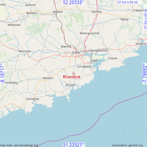
Riverstick GPS coordinates[2]
51° 46' 20.604" North, 8° 29' 38.544" West
| Map corner | latitude | longitude |
|---|---|---|
| Upper-left | 52.20538°, | -9.19717° |
| Center: | 51.77239°, | -8.49404° |
| Lower-right: | 51.33521°, | -7.79092° |
| Map W x H: | 96.8×96.8 km | = 60.1×60.1mi |
| max Lat: | 55.25° ⇑97.3% North |
| Riverstick: | 51.77239° |
| min Lat: | ⇓2.7% South 51.52487° |
| min Long | Riverstick | max Long |
| -10.26889° | -8.49404° | -6.04944° |
| W 25.6%⇐ | ⇒74.4% E |
Elevation
Elevation of Riverstick is 42 m = 138 ft, and this is 12.5 m = 41 ft below average elevation for this country.
| Max E: |
262 m = 860 ft | 55.8% |
| Avg. | 54.5 m = 179 ft | |
| Riverstick | 42 m = 138 ft | |
Min E: |
0 m = 0 ft | 44.2% |
See also: Ireland elevation on elevation.city.
Geographical zone
Riverstick is located in North temperate zone (between Tropic of Cancer and the Arctic Circle). Distance of this North polar circle is 1644.6 km =1021.9 mi to North.| Distance of | km | miles | from Riverstick |
|---|---|---|---|
| North Pole | 4250.5 | 2641.1 | to North |
| Arctic Circle | 1644.6 | 1021.9 | to North |
| Tropic Cancer | 3150.6 | 1957.7 | to South |
| Equator | 5756.6 | 3577 | to South |


Nearby cities:
15 places around Riverstick: (largest is in red/bold)
• Ballygarvan
5.9 km =3.7 mi,  21°
21°
• Bandon
17.3 km =10.7 mi,  260°
260°
• Belgooly
3.7 km =2.3 mi,  175°
175°
• Blarney
18.6 km =11.6 mi,  344°
344°
• Carrigaline
7.9 km =4.9 mi,  56°
56°
• Cobh
16.2 km =10.1 mi, 57°
• Cork
14.1 km =8.8 mi,  6°
6°
• Crosshaven
13.6 km =8.5 mi,  77°
77°
• Fountainstown
13.3 km =8.3 mi, 84°
• Innishannon
11.2 km =7 mi,  266°
266°
• Killumney
15.3 km =9.5 mi,  316°
316°
• Kinsale
7.6 km =4.7 mi,  199°
199°
• Passage West
15.3 km =9.5 mi,  42°
42°
• Rathard
18.8 km =11.7 mi,  296°
296°
• Tower
18.8 km =11.7 mi, 335°
Sources, notices
• [Note1] Compared only with cities in Ireland existing in our database
• [Src1] Map data: © OpenStreetMap contributors (CC-BY-SA)
• [Src2] Other city data from geonames.org with taken over terms of usage.
• [Src3] Geographical zone / Annual Mean Temperature by Robert A. Rohde @ Wikipedia
