Fountainstown geodata
Fountainstown (Munster) is a populated place; located in Ireland in Europe/Dublin (GMT+1) time zone. With population of 894 people, there are 367 cities with bigger population in this country. Compared to other cities in Ireland, 97.2% of cities are located further ↑North; 70.2% of cities are located further →East and 50.7% of cities have lower elevation than Fountainstown. Note1


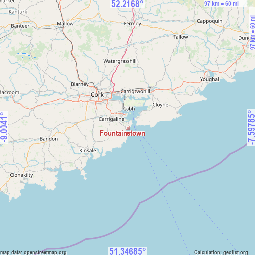
Fountainstown GPS coordinates[2]
51° 47' 2.112" North, 8° 18' 3.492" West
| Map corner | latitude | longitude |
|---|---|---|
| Upper-left | 52.2168°, | -9.0041° |
| Center: | 51.78392°, | -8.30097° |
| Lower-right: | 51.34685°, | -7.59785° |
| Map W x H: | 96.7×96.7 km | = 60.1×60.1mi |
| max Lat: | 55.25° ⇑97.2% North |
| Fountainstown: | 51.78392° |
| min Lat: | ⇓2.8% South 51.52487° |
| min Long | Fountainstown | max Long |
| -10.26889° | -8.30097° | -6.04944° |
| W 29.8%⇐ | ⇒70.2% E |
Elevation
Elevation of Fountainstown is 52 m = 171 ft, and this is 2.5 m = 8 ft below average elevation for this country.
| Max E: |
262 m = 860 ft | 49.3% |
| Avg. | 54.5 m = 179 ft | |
| Fountainstown | 52 m = 171 ft | |
Min E: |
0 m = 0 ft | 50.7% |
See also: Ireland elevation on elevation.city.
Geographical zone
Fountainstown is located in North temperate zone (between Tropic of Cancer and the Arctic Circle). Distance of this North polar circle is 1643.3 km =1021.1 mi to North.| Distance of | km | miles | from Fountainstown |
|---|---|---|---|
| North Pole | 4249.2 | 2640.3 | to North |
| Arctic Circle | 1643.3 | 1021.1 | to North |
| Tropic Cancer | 3151.9 | 1958.5 | to South |
| Equator | 5757.8 | 3577.7 | to South |


Nearby cities:
15 places around Fountainstown: (largest is in red/bold)
• Aghada
8.7 km =5.4 mi,  44°
44°
• Ballygarvan
11.9 km =7.4 mi,  290°
290°
• Belgooly
13.9 km =8.6 mi,  248°
248°
• Carrigaline
7.4 km =4.6 mi, 294°
• Carrigtwohill
14.1 km =8.8 mi,  10°
10°
• Castlemartyr
22 km =13.7 mi,  50°
50°
• Cloyne
15 km =9.3 mi, 54°
• Cobh
7.4 km =4.6 mi,  3°
3°
• Cork
17.2 km =10.7 mi,  317°
317°
• Crosshaven
1.6 km =1 mi, 0°
• Kinsale
17.9 km =11.1 mi,  241°
241°
• Midleton
16.8 km =10.4 mi,  29°
29°
• Passage West
10.4 km =6.5 mi,  343°
343°
• Riverstick
13.3 km =8.3 mi,  264°
264°
• Whitegate
7.1 km =4.4 mi, 43°
Sources, notices
• [Note1] Compared only with cities in Ireland existing in our database
• [Src1] Map data: © OpenStreetMap contributors (CC-BY-SA)
• [Src2] Other city data from geonames.org with taken over terms of usage.
• [Src3] Geographical zone / Annual Mean Temperature by Robert A. Rohde @ Wikipedia
