Killeagh geodata
Killeagh (Munster) is a populated place; located in Ireland in Europe/Dublin (GMT+1) time zone. With population of 721 people, there are 425 cities with bigger population in this country. Compared to other cities in Ireland, 93.4% of cities are located further ↑North; 62.8% of cities are located further →East and 77.2% of cities have higher elevation than Killeagh. Note1


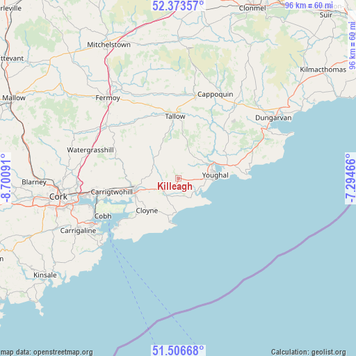
Killeagh GPS coordinates[2]
51° 56' 31.992" North, 7° 59' 52.008" West
| Map corner | latitude | longitude |
|---|---|---|
| Upper-left | 52.37357°, | -8.70091° |
| Center: | 51.94222°, | -7.99778° |
| Lower-right: | 51.50668°, | -7.29466° |
| Map W x H: | 96.4×96.4 km | = 59.9×59.9mi |
| max Lat: | 55.25° ⇑93.4% North |
| Killeagh: | 51.94222° |
| min Lat: | ⇓6.6% South 51.52487° |
| min Long | Killeagh | max Long |
| -10.26889° | -7.99778° | -6.04944° |
| W 37.2%⇐ | ⇒62.8% E |
Elevation
Elevation of Killeagh is 19 m = 62 ft, and this is 35.5 m = 116 ft below average elevation for this country.
| Max E: |
262 m = 860 ft | 77.2% |
| Avg. | 54.5 m = 179 ft | |
| Killeagh | 19 m = 62 ft | |
Min E: |
0 m = 0 ft | 22.8% |
See also: Ireland elevation on elevation.city.
Geographical zone
Killeagh is located in North temperate zone (between Tropic of Cancer and the Arctic Circle). Distance of this North polar circle is 1625.7 km =1010.2 mi to North.| Distance of | km | miles | from Killeagh |
|---|---|---|---|
| North Pole | 4231.6 | 2629.4 | to North |
| Arctic Circle | 1625.7 | 1010.2 | to North |
| Tropic Cancer | 3169.5 | 1969.4 | to South |
| Equator | 5775.4 | 3588.7 | to South |


Nearby cities:
15 places around Killeagh: (largest is in red/bold)
• Aghada
18.7 km =11.6 mi,  232°
232°
• Cappoquin
24.8 km =15.4 mi,  23°
23°
• Carrigtwohill
18.6 km =11.6 mi,  258°
258°
• Castlemartyr
5.2 km =3.2 mi, 227°
• Cloyne
12.4 km =7.7 mi,  224°
224°
• Cobh
22.8 km =14.2 mi,  243°
243°
• Crosshaven
26.2 km =16.3 mi, 232°
• Fountainstown
27.3 km =17 mi, 229°
• Midleton
12.9 km =8 mi, 256°
• Passage West
25 km =15.5 mi,  252°
252°
• Rathcormac
24.5 km =15.2 mi,  307°
307°
• Tallow
16.8 km =10.4 mi,  357°
357°
• Watergrasshill
24.9 km =15.5 mi,  287°
287°
• Whitegate
20.2 km =12.6 mi, 232°
• Youghal
10.1 km =6.3 mi,  85°
85°
Sources, notices
• [Note1] Compared only with cities in Ireland existing in our database
• [Src1] Map data: © OpenStreetMap contributors (CC-BY-SA)
• [Src2] Other city data from geonames.org with taken over terms of usage.
• [Src3] Geographical zone / Annual Mean Temperature by Robert A. Rohde @ Wikipedia
