Cork geodata
Cork (Munster) is a seat of a second-order administrative division; located in Ireland in Europe/Dublin (GMT+1) time zone. With population of 190,384 people, there is 1 city with bigger population in this country. Compared to other cities in Ireland, 94.7% of cities are located further ↑North; 74% of cities are located further →East and 89.6% of cities have higher elevation than Cork. Note1


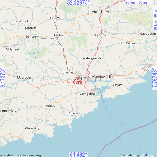
Cork GPS coordinates[2]
51° 53' 52.692" North, 8° 28' 14.196" West
| Map corner | latitude | longitude |
|---|---|---|
| Upper-left | 52.32975°, | -9.17373° |
| Center: | 51.89797°, | -8.47061° |
| Lower-right: | 51.462°, | -7.76748° |
| Map W x H: | 96.5×96.5 km | = 60×60mi |
| max Lat: | 55.25° ⇑94.7% North |
| Cork: | 51.89797° |
| min Lat: | ⇓5.3% South 51.52487° |
| min Long | Cork | max Long |
| -10.26889° | -8.47061° | -6.04944° |
| W 26%⇐ | ⇒74% E |
Elevation
Elevation of Cork is 10 m = 33 ft, and this is 44.5 m = 146 ft below average elevation for this country.
| Max E: |
262 m = 860 ft | 89.6% |
| Avg. | 54.5 m = 179 ft | |
| Cork | 10 m = 33 ft | |
Min E: |
0 m = 0 ft | 10.4% |
See also: Cork elevation on elevation.city.
Geographical zone
Cork is located in North temperate zone (between Tropic of Cancer and the Arctic Circle). Distance of this North polar circle is 1630.7 km =1013.3 mi to North.| Distance of | km | miles | from Cork |
|---|---|---|---|
| North Pole | 4236.5 | 2632.4 | to North |
| Arctic Circle | 1630.7 | 1013.3 | to North |
| Tropic Cancer | 3164.6 | 1966.4 | to South |
| Equator | 5770.5 | 3585.6 | to South |


Nearby cities:
15 places around Cork: (largest is in red/bold)
• Ballygarvan
8.5 km =5.3 mi,  176°
176°
• Blarney
7.7 km =4.8 mi,  300°
300°
• Carrigaline
10.8 km =6.7 mi,  152°
152°
• Carrigtwohill
14.3 km =8.9 mi,  85°
85°
• Cobh
13.2 km =8.2 mi,  113°
113°
• Courtbrack
14.3 km =8.9 mi, 302°
• Crosshaven
16.1 km =10 mi,  133°
133°
• Fountainstown
17.2 km =10.7 mi,  137°
137°
• Grenagh
16.1 km =10 mi,  324°
324°
• Killumney
12.5 km =7.8 mi,  256°
256°
• Passage West
9.1 km =5.7 mi, 107°
• Riverstick
14.1 km =8.8 mi,  186°
186°
• Tower
9.9 km =6.2 mi,  288°
288°
• Watergrasshill
15.3 km =9.5 mi,  34°
34°
• Whitechurch
9.7 km =6 mi,  342°
342°
Sources, notices
• [Note1] Compared only with cities in Ireland existing in our database
• [Src1] Map data: © OpenStreetMap contributors (CC-BY-SA)
• [Src2] Other city data from geonames.org with taken over terms of usage.
• [Src3] Geographical zone / Annual Mean Temperature by Robert A. Rohde @ Wikipedia
