Tarbert geodata
Tarbert (Munster) is a populated place; located in Ireland in Europe/Dublin (GMT+1) time zone. With population of 551 people, there are 499 cities with bigger population in this country. Compared to other cities in Ireland, 77.2% of cities are located further ↑North; 94.7% of cities are located further →East and 89.6% of cities have higher elevation than Tarbert. Note1


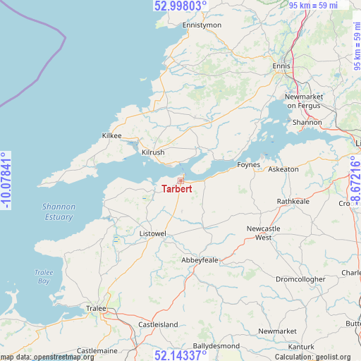
Tarbert GPS coordinates[2]
52° 34' 22.008" North, 9° 22' 31.008" West
| Map corner | latitude | longitude |
|---|---|---|
| Upper-left | 52.99803°, | -10.07841° |
| Center: | 52.57278°, | -9.37528° |
| Lower-right: | 52.14337°, | -8.67216° |
| Map W x H: | 95×95 km | = 59×59mi |
| max Lat: | 55.25° ⇑77.2% North |
| Tarbert: | 52.57278° |
| min Lat: | ⇓22.8% South 51.52487° |
| min Long | Tarbert | max Long |
| -10.26889° | -9.37528° | -6.04944° |
| W 5.3%⇐ | ⇒94.7% E |
Elevation
Elevation of Tarbert is 10 m = 33 ft, and this is 44.5 m = 146 ft below average elevation for this country.
| Max E: |
262 m = 860 ft | 89.6% |
| Avg. | 54.5 m = 179 ft | |
| Tarbert | 10 m = 33 ft | |
Min E: |
0 m = 0 ft | 10.4% |
See also: Ireland elevation on elevation.city.
Geographical zone
Tarbert is located in North temperate zone (between Tropic of Cancer and the Arctic Circle). Distance of this North polar circle is 1555.6 km =966.6 mi to North.| Distance of | km | miles | from Tarbert |
|---|---|---|---|
| North Pole | 4161.5 | 2585.8 | to North |
| Arctic Circle | 1555.6 | 966.6 | to North |
| Tropic Cancer | 3239.6 | 2013 | to South |
| Equator | 5845.5 | 3632.2 | to South |


Nearby cities:
15 places around Tarbert: (largest is in red/bold)
• Abbeyfeale
21.8 km =13.5 mi,  166°
166°
• Askeaton
27.2 km =16.9 mi,  83°
83°
• Ballingarry
36.3 km =22.6 mi,  107°
107°
• Ballybunnion
21.1 km =13.1 mi,  251°
251°
• Ballyduff
23.7 km =14.7 mi,  235°
235°
• Foynes
18.4 km =11.4 mi, 76°
• Glin
6.3 km =3.9 mi,  92°
92°
• Kilrush
10.4 km =6.5 mi,  315°
315°
• Listowel
15.9 km =9.9 mi,  207°
207°
• Lixnaw
24.8 km =15.4 mi,  221°
221°
• Miltown Malbay
31.4 km =19.5 mi,  357°
357°
• Newcastle West
25.3 km =15.7 mi,  122°
122°
• Pallaskenry
35.1 km =21.8 mi, 77°
• Rathkeale
30 km =18.6 mi,  100°
100°
• Shannon
37.4 km =23.2 mi,  67°
67°
Sources, notices
• [Note1] Compared only with cities in Ireland existing in our database
• [Src1] Map data: © OpenStreetMap contributors (CC-BY-SA)
• [Src2] Other city data from geonames.org with taken over terms of usage.
• [Src3] Geographical zone / Annual Mean Temperature by Robert A. Rohde @ Wikipedia
