Abbeyfeale geodata
Abbeyfeale (Munster) is a populated place; located in Ireland in Europe/Dublin (GMT+1) time zone. With population of 2,007 people, there are 230 cities with bigger population in this country. Compared to other cities in Ireland, 82.9% of cities are located further ↑North; 93.9% of cities are located further →East and 58.4% of cities have lower elevation than Abbeyfeale. Note1


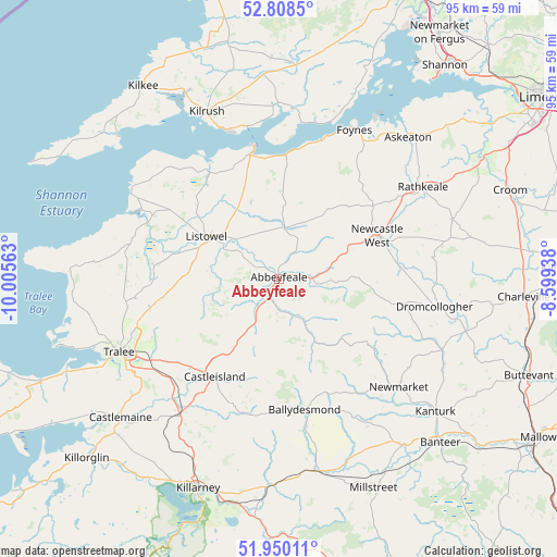
Abbeyfeale GPS coordinates[2]
52° 22' 53.004" North, 9° 18' 9" West
| Map corner | latitude | longitude |
|---|---|---|
| Upper-left | 52.8085°, | -10.00563° |
| Center: | 52.38139°, | -9.3025° |
| Lower-right: | 51.95011°, | -8.59938° |
| Map W x H: | 95.4×95.4 km | = 59.3×59.3mi |
| max Lat: | 55.25° ⇑82.9% North |
| Abbeyfeale: | 52.38139° |
| min Lat: | ⇓17.1% South 51.52487° |
| min Long | Abbeyfeale | max Long |
| -10.26889° | -9.3025° | -6.04944° |
| W 6.1%⇐ | ⇒93.9% E |
Elevation
Elevation of Abbeyfeale is 59 m = 194 ft, and this is 4.5 m = 15 ft above average elevation for this country.
| Max E: |
262 m = 860 ft | 41.6% |
| Abbeyfeale | 59 m 194 ft | |
| Avg. | 54.5 m = 179 ft | |
Min E: |
0 m = 0 ft | 58.4% |
See also: Ireland elevation on elevation.city.
Geographical zone
Abbeyfeale is located in North temperate zone (between Tropic of Cancer and the Arctic Circle). Distance of this North polar circle is 1576.9 km =979.8 mi to North.| Distance of | km | miles | from Abbeyfeale |
|---|---|---|---|
| North Pole | 4182.8 | 2599.1 | to North |
| Arctic Circle | 1576.9 | 979.8 | to North |
| Tropic Cancer | 3218.3 | 1999.8 | to South |
| Equator | 5824.3 | 3619.1 | to South |


Nearby cities:
15 places around Abbeyfeale: (largest is in red/bold)
• Ballingarry
31.4 km =19.5 mi,  71°
71°
• Ballybunnion
28.8 km =17.9 mi,  300°
300°
• Ballyduff
25.6 km =15.9 mi,  287°
287°
• Castleisland
19.9 km =12.4 mi,  214°
214°
• Dromcollogher
27.2 km =16.9 mi,  99°
99°
• Foynes
28.7 km =17.8 mi,  26°
26°
• Glin
21 km =13 mi,  3°
3°
• Kilrush
31.2 km =19.4 mi,  336°
336°
• Listowel
14.3 km =8.9 mi, 300°
• Lixnaw
21.5 km =13.4 mi,  277°
277°
• Newcastle West
18 km =11.2 mi, 65°
• Newmarket
27.5 km =17.1 mi,  131°
131°
• Rathkeale
29.4 km =18.3 mi,  57°
57°
• Tarbert
21.8 km =13.5 mi,  346°
346°
• Tralee
29.9 km =18.6 mi,  245°
245°
Sources, notices
• [Note1] Compared only with cities in Ireland existing in our database
• [Src1] Map data: © OpenStreetMap contributors (CC-BY-SA)
• [Src2] Other city data from geonames.org with taken over terms of usage.
• [Src3] Geographical zone / Annual Mean Temperature by Robert A. Rohde @ Wikipedia
