Ballyduff geodata
Ballyduff (Munster) is a populated place; located in Ireland in Europe/Dublin (GMT+1) time zone. With population of 532 people, there are 509 cities with bigger population in this country. Compared to other cities in Ireland, 81% of cities are located further ↑North; 97.2% of cities are located further →East and 60.2% of cities have higher elevation than Ballyduff. Note1


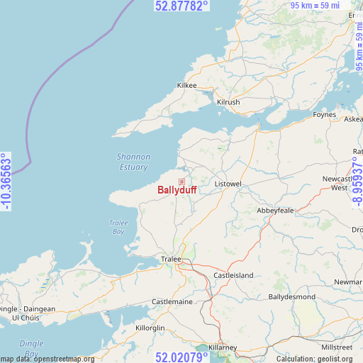
Ballyduff GPS coordinates[2]
52° 27' 5.004" North, 9° 39' 45" West
| Map corner | latitude | longitude |
|---|---|---|
| Upper-left | 52.87782°, | -10.36563° |
| Center: | 52.45139°, | -9.6625° |
| Lower-right: | 52.02079°, | -8.95937° |
| Map W x H: | 95.3×95.3 km | = 59.2×59.2mi |
| max Lat: | 55.25° ⇑81% North |
| Ballyduff: | 52.45139° |
| min Lat: | ⇓19% South 51.52487° |
| min Long | Ballyduff | max Long |
| -10.26889° | -9.6625° | -6.04944° |
| W 2.8%⇐ | ⇒97.2% E |
Elevation
Elevation of Ballyduff is 37 m = 121 ft, and this is 17.5 m = 57 ft below average elevation for this country.
| Max E: |
262 m = 860 ft | 60.2% |
| Avg. | 54.5 m = 179 ft | |
| Ballyduff | 37 m = 121 ft | |
Min E: |
0 m = 0 ft | 39.8% |
See also: Ireland elevation on elevation.city.
Geographical zone
Ballyduff is located in North temperate zone (between Tropic of Cancer and the Arctic Circle). Distance of this North polar circle is 1569.1 km =975 mi to North.| Distance of | km | miles | from Ballyduff |
|---|---|---|---|
| North Pole | 4175 | 2594.2 | to North |
| Arctic Circle | 1569.1 | 975 | to North |
| Tropic Cancer | 3226.1 | 2004.6 | to South |
| Equator | 5832 | 3623.8 | to South |


Nearby cities:
15 places around Ballyduff: (largest is in red/bold)
• Abbeyfeale
25.6 km =15.9 mi,  107°
107°
• Ardfert
16.3 km =10.1 mi,  208°
208°
• Baile an Mhuilinn
33.7 km =20.9 mi,  186°
186°
• Ballybunnion
6.7 km =4.2 mi,  355°
355°
• Ballyheige
13.9 km =8.6 mi,  236°
236°
• Castleisland
27.7 km =17.2 mi,  151°
151°
• Fenit
23.5 km =14.6 mi,  216°
216°
• Glin
28.9 km =18 mi,  62°
62°
• Killorglin
39.9 km =24.8 mi, 191°
• Kilrush
24.2 km =15 mi,  30°
30°
• Listowel
12 km =7.5 mi,  92°
92°
• Lixnaw
6 km =3.7 mi, 148°
• Newcastle West
40.8 km =25.4 mi, 90°
• Tarbert
23.7 km =14.7 mi, 55°
• Tralee
20.3 km =12.6 mi, 187°
Sources, notices
• [Note1] Compared only with cities in Ireland existing in our database
• [Src1] Map data: © OpenStreetMap contributors (CC-BY-SA)
• [Src2] Other city data from geonames.org with taken over terms of usage.
• [Src3] Geographical zone / Annual Mean Temperature by Robert A. Rohde @ Wikipedia
