Ringsend geodata
Ringsend (Leinster) is a section of populated place; located in Ireland in Europe/Dublin (GMT+1) time zone. With population of 8,202 people, there are 77 cities with bigger population in this country. Compared to other cities in Ireland, 60.2% of cities are located further ↓South; 88.8% of cities are located further ←West and 98.1% of cities have higher elevation than Ringsend. Note1


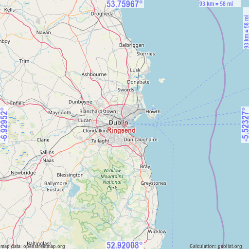
Ringsend GPS coordinates[2]
53° 20' 30.984" North, 6° 13' 35.004" West
| Map corner | latitude | longitude |
|---|---|---|
| Upper-left | 53.75967°, | -6.92952° |
| Center: | 53.34194°, | -6.22639° |
| Lower-right: | 52.92008°, | -5.52327° |
| Map W x H: | 93.4×93.4 km | = 58×58mi |
| max Lat: | 55.25° ⇑39.8% North |
| Ringsend: | 53.34194° |
| min Lat: | ⇓60.2% South 51.52487° |
| min Long | Ringsend | max Long |
| -10.26889° | -6.22639° | -6.04944° |
| W 88.8%⇐ | ⇒11.2% E |
Elevation
Elevation of Ringsend is 4 m = 13 ft, and this is 50.5 m = 166 ft below average elevation for this country.
| Max E: |
262 m = 860 ft | 98.1% |
| Avg. | 54.5 m = 179 ft | |
| Ringsend | 4 m = 13 ft | |
Min E: |
0 m = 0 ft | 1.9% |
See also: Ireland elevation on elevation.city.
Geographical zone
Ringsend is located in North temperate zone (between Tropic of Cancer and the Arctic Circle). Distance of this North polar circle is 1470.1 km =913.5 mi to North.| Distance of | km | miles | from Ringsend |
|---|---|---|---|
| North Pole | 4076 | 2532.7 | to North |
| Arctic Circle | 1470.1 | 913.5 | to North |
| Tropic Cancer | 3325.1 | 2066.1 | to South |
| Equator | 5931.1 | 3685.4 | to South |


Nearby cities:
15 places around Ringsend: (largest is in red/bold)
• Booterstown
4.5 km =2.8 mi,  157°
157°
• Clonskeagh
3.1 km =1.9 mi,  186°
186°
• Dollymount
4 km =2.5 mi,  50°
50°
• Donnybrook
3.1 km =1.9 mi,  175°
175°
• Donnycarney
3.7 km =2.3 mi,  17°
17°
• Drumcondra
3.6 km =2.2 mi,  331°
331°
• Dublin
1.8 km =1.1 mi,  236°
236°
• Fairview
2.8 km =1.7 mi,  341°
341°
• Killester
3.8 km =2.4 mi, 22°
• Marino
3.2 km =2 mi,  348°
348°
• Milltown
3.5 km =2.2 mi,  201°
201°
• Mount Merrion
4.7 km =2.9 mi,  170°
170°
• Rathgar
4.4 km =2.7 mi,  226°
226°
• Rathmines
3.4 km =2.1 mi, 225°
• Sandymount
1.6 km =1 mi, 169°
Sources, notices
• [Note1] Compared only with cities in Ireland existing in our database
• [Src1] Map data: © OpenStreetMap contributors (CC-BY-SA)
• [Src2] Other city data from geonames.org with taken over terms of usage.
• [Src3] Geographical zone / Annual Mean Temperature by Robert A. Rohde @ Wikipedia
