Askeaton geodata
Askeaton (Munster) is a populated place; located in Ireland in Europe/Dublin (GMT+1) time zone. With population of 1,149 people, there are 324 cities with bigger population in this country. Compared to other cities in Ireland, 76.3% of cities are located further ↑North; 88.6% of cities are located further →East and 93.9% of cities have higher elevation than Askeaton. Note1


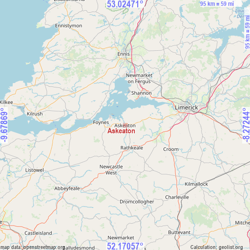
Askeaton GPS coordinates[2]
52° 35' 58.992" North, 8° 58' 32.016" West
| Map corner | latitude | longitude |
|---|---|---|
| Upper-left | 53.02471°, | -9.67869° |
| Center: | 52.59972°, | -8.97556° |
| Lower-right: | 52.17057°, | -8.27244° |
| Map W x H: | 95×95 km | = 59×59mi |
| max Lat: | 55.25° ⇑76.3% North |
| Askeaton: | 52.59972° |
| min Lat: | ⇓23.7% South 51.52487° |
| min Long | Askeaton | max Long |
| -10.26889° | -8.97556° | -6.04944° |
| W 11.4%⇐ | ⇒88.6% E |
Elevation
Elevation of Askeaton is 7 m = 23 ft, and this is 47.5 m = 156 ft below average elevation for this country.
| Max E: |
262 m = 860 ft | 93.9% |
| Avg. | 54.5 m = 179 ft | |
| Askeaton | 7 m = 23 ft | |
Min E: |
0 m = 0 ft | 6.1% |
See also: Ireland elevation on elevation.city.
Geographical zone
Askeaton is located in North temperate zone (between Tropic of Cancer and the Arctic Circle). Distance of this North polar circle is 1552.6 km =964.7 mi to North.| Distance of | km | miles | from Askeaton |
|---|---|---|---|
| North Pole | 4158.5 | 2584 | to North |
| Arctic Circle | 1552.6 | 964.7 | to North |
| Tropic Cancer | 3242.6 | 2014.9 | to South |
| Equator | 5848.5 | 3634.1 | to South |


Nearby cities:
15 places around Askeaton: (largest is in red/bold)
• Adare
12.9 km =8 mi,  109°
109°
• Ballingarry
16 km =9.9 mi,  151°
151°
• Ballycannan
24.7 km =15.3 mi,  62°
62°
• Cratloe
18 km =11.2 mi,  53°
53°
• Croom
19.6 km =12.2 mi,  117°
117°
• Foynes
9.2 km =5.7 mi,  278°
278°
• Glin
21 km =13 mi,  261°
261°
• Moyross
24.4 km =15.2 mi,  68°
68°
• Newcastle West
17.7 km =11 mi,  199°
199°
• Newmarket on Fergus
18.6 km =11.6 mi,  16°
16°
• Pallaskenry
8.7 km =5.4 mi, 56°
• Patrickswell
18 km =11.2 mi,  90°
90°
• Rathkeale
8.7 km =5.4 mi,  163°
163°
• Shannon
13.8 km =8.6 mi,  32°
32°
• Sixmilebridge
20.8 km =12.9 mi,  40°
40°
Sources, notices
• [Note1] Compared only with cities in Ireland existing in our database
• [Src1] Map data: © OpenStreetMap contributors (CC-BY-SA)
• [Src2] Other city data from geonames.org with taken over terms of usage.
• [Src3] Geographical zone / Annual Mean Temperature by Robert A. Rohde @ Wikipedia
