Miltown Malbay geodata
Miltown Malbay (Munster) is a populated place; located in Ireland in Europe/Dublin (GMT+1) time zone. With population of 777 people, there are 410 cities with bigger population in this country. Compared to other cities in Ireland, 65.7% of cities are located further ↑North; 94.9% of cities are located further →East and 56.5% of cities have lower elevation than Miltown Malbay. Note1


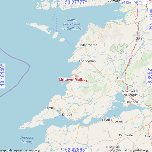
Miltown Malbay GPS coordinates[2]
52° 51' 19.008" North, 9° 23' 53.988" West
| Map corner | latitude | longitude |
|---|---|---|
| Upper-left | 53.27777°, | -10.10146° |
| Center: | 52.85528°, | -9.39833° |
| Lower-right: | 52.42863°, | -8.6952° |
| Map W x H: | 94.4×94.4 km | = 58.7×58.7mi |
| max Lat: | 55.25° ⇑65.7% North |
| Miltown Malbay: | 52.85528° |
| min Lat: | ⇓34.3% South 51.52487° |
| min Long | Miltown Malbay | max Long |
| -10.26889° | -9.39833° | -6.04944° |
| W 5.1%⇐ | ⇒94.9% E |
Elevation
Elevation of Miltown Malbay is 57 m = 187 ft, and this is 2.5 m = 8 ft above average elevation for this country.
| Max E: |
262 m = 860 ft | 43.5% |
| Miltown Malbay | 57 m 187 ft | |
| Avg. | 54.5 m = 179 ft | |
Min E: |
0 m = 0 ft | 56.5% |
See also: Ireland elevation on elevation.city.
Geographical zone
Miltown Malbay is located in North temperate zone (between Tropic of Cancer and the Arctic Circle). Distance of this North polar circle is 1524.2 km =947.1 mi to North.| Distance of | km | miles | from Miltown Malbay |
|---|---|---|---|
| North Pole | 4130.1 | 2566.3 | to North |
| Arctic Circle | 1524.2 | 947.1 | to North |
| Tropic Cancer | 3271 | 2032.5 | to South |
| Equator | 5877 | 3651.8 | to South |


Nearby cities:
15 places around Miltown Malbay: (largest is in red/bold)
• Askeaton
40.2 km =25 mi,  134°
134°
• Ballybunnion
42.5 km =26.4 mi,  205°
205°
• Boston
36.9 km =22.9 mi,  58°
58°
• Corofin
24.7 km =15.3 mi,  65°
65°
• Ennis
27.7 km =17.2 mi,  92°
92°
• Ennistimon
12.2 km =7.6 mi,  35°
35°
• Foynes
33.3 km =20.7 mi,  144°
144°
• Glin
32.6 km =20.3 mi,  166°
166°
• Kilrush
24.6 km =15.3 mi,  193°
193°
• Lehinch
9.5 km =5.9 mi,  25°
25°
• Lisdoonvarna
21.1 km =13.1 mi,  20°
20°
• Newmarket on Fergus
35.4 km =22 mi,  107°
107°
• Quin
35.9 km =22.3 mi,  96°
96°
• Shannon
39.7 km =24.7 mi,  115°
115°
• Tarbert
31.4 km =19.5 mi,  177°
177°
Sources, notices
• [Note1] Compared only with cities in Ireland existing in our database
• [Src1] Map data: © OpenStreetMap contributors (CC-BY-SA)
• [Src2] Other city data from geonames.org with taken over terms of usage.
• [Src3] Geographical zone / Annual Mean Temperature by Robert A. Rohde @ Wikipedia
