Collon geodata
Collon (Leinster) is a populated place; located in Ireland in Europe/Dublin (GMT+1) time zone. With population of 814 people, there are 394 cities with bigger population in this country. Compared to other cities in Ireland, 81% of cities are located further ↓South; 74.8% of cities are located further ←West and 96.6% of cities have lower elevation than Collon. Note1


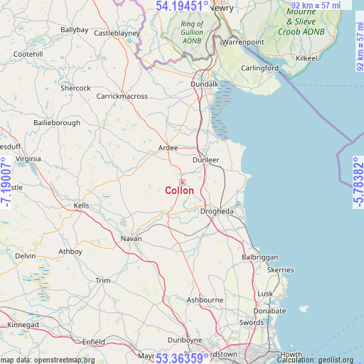
Collon GPS coordinates[2]
53° 46' 51.996" North, 6° 29' 12.984" West
| Map corner | latitude | longitude |
|---|---|---|
| Upper-left | 54.19451°, | -7.19007° |
| Center: | 53.78111°, | -6.48694° |
| Lower-right: | 53.36359°, | -5.78382° |
| Map W x H: | 92.4×92.4 km | = 57.4×57.4mi |
| max Lat: | 55.25° ⇑19% North |
| Collon: | 53.78111° |
| min Lat: | ⇓81% South 51.52487° |
| min Long | Collon | max Long |
| -10.26889° | -6.48694° | -6.04944° |
| W 74.8%⇐ | ⇒25.2% E |
Elevation
Elevation of Collon is 138 m = 453 ft, and this is 83.5 m = 274 ft above average elevation for this country.
| Max E: |
262 m = 860 ft | 3.4% |
| Collon | 138 m 453 ft | |
| Avg. | 54.5 m = 179 ft | |
Min E: |
0 m = 0 ft | 96.6% |
See also: Ireland elevation on elevation.city.
Geographical zone
Collon is located in North temperate zone (between Tropic of Cancer and the Arctic Circle). Distance of this North polar circle is 1421.3 km =883.2 mi to North.| Distance of | km | miles | from Collon |
|---|---|---|---|
| North Pole | 4027.2 | 2502.4 | to North |
| Arctic Circle | 1421.3 | 883.2 | to North |
| Tropic Cancer | 3374 | 2096.5 | to South |
| Equator | 5979.9 | 3715.7 | to South |


Nearby cities:
15 places around Collon: (largest is in red/bold)
• Ardee
9.4 km =5.8 mi,  338°
338°
• Castlebellingham
14.7 km =9.1 mi,  25°
25°
• Clogherhead
16.4 km =10.2 mi,  85°
85°
• Donore
10.7 km =6.6 mi,  155°
155°
• Drogheda
11.5 km =7.1 mi,  127°
127°
• Dromiskin
17 km =10.6 mi,  18°
18°
• Duleek
14.5 km =9 mi, 162°
• Dunleer
8.5 km =5.3 mi,  44°
44°
• Julianstown
17.9 km =11.1 mi, 132°
• Kentstown
17.3 km =10.7 mi,  188°
188°
• Louth
19 km =11.8 mi,  349°
349°
• Slane
8.7 km =5.4 mi,  205°
205°
• Tallanstown
16.2 km =10.1 mi, 346°
• Termonfeckin
14.5 km =9 mi,  97°
97°
• Tullyallen
6.5 km =4 mi,  139°
139°
Sources, notices
• [Note1] Compared only with cities in Ireland existing in our database
• [Src1] Map data: © OpenStreetMap contributors (CC-BY-SA)
• [Src2] Other city data from geonames.org with taken over terms of usage.
• [Src3] Geographical zone / Annual Mean Temperature by Robert A. Rohde @ Wikipedia
