Tullyallen geodata
Tullyallen (Leinster) is a populated place; located in Ireland in Europe/Dublin (GMT+1) time zone. With population of 1,358 people, there are 292 cities with bigger population in this country. Compared to other cities in Ireland, 79.5% of cities are located further ↓South; 77% of cities are located further ←West and 66% of cities have lower elevation than Tullyallen. Note1


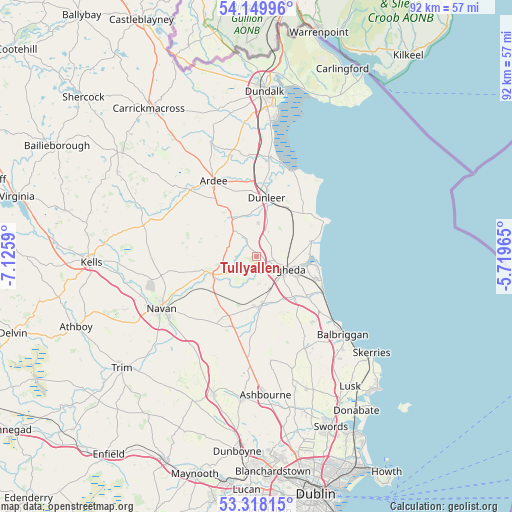
Tullyallen GPS coordinates[2]
53° 44' 9.996" North, 6° 25' 22.008" West
| Map corner | latitude | longitude |
|---|---|---|
| Upper-left | 54.14996°, | -7.1259° |
| Center: | 53.73611°, | -6.42278° |
| Lower-right: | 53.31815°, | -5.71965° |
| Map W x H: | 92.5×92.5 km | = 57.5×57.5mi |
| max Lat: | 55.25° ⇑20.5% North |
| Tullyallen: | 53.73611° |
| min Lat: | ⇓79.5% South 51.52487° |
| min Long | Tullyallen | max Long |
| -10.26889° | -6.42278° | -6.04944° |
| W 77%⇐ | ⇒23% E |
Elevation
Elevation of Tullyallen is 65 m = 213 ft, and this is 10.5 m = 34 ft above average elevation for this country.
| Max E: |
262 m = 860 ft | 34% |
| Tullyallen | 65 m 213 ft | |
| Avg. | 54.5 m = 179 ft | |
Min E: |
0 m = 0 ft | 66% |
See also: Ireland elevation on elevation.city.
Geographical zone
Tullyallen is located in North temperate zone (between Tropic of Cancer and the Arctic Circle). Distance of this North polar circle is 1426.3 km =886.3 mi to North.| Distance of | km | miles | from Tullyallen |
|---|---|---|---|
| North Pole | 4032.2 | 2505.5 | to North |
| Arctic Circle | 1426.3 | 886.3 | to North |
| Tropic Cancer | 3369 | 2093.4 | to South |
| Equator | 5974.9 | 3712.6 | to South |


Nearby cities:
15 places around Tullyallen: (largest is in red/bold)
• Ardee
15.8 km =9.8 mi,  330°
330°
• Castlebellingham
18.4 km =11.4 mi,  6°
6°
• Clogherhead
13.8 km =8.6 mi,  62°
62°
• Collon
6.5 km =4 mi,  319°
319°
• Donore
4.8 km =3 mi,  177°
177°
• Drogheda
5.3 km =3.3 mi,  111°
111°
• Duleek
8.8 km =5.5 mi, 178°
• Dunleer
11.1 km =6.9 mi, 9°
• Julianstown
11.5 km =7.1 mi,  127°
127°
• Kentstown
13.9 km =8.6 mi,  209°
209°
• Laytown
13.5 km =8.4 mi,  116°
116°
• Navan
19.4 km =12.1 mi,  241°
241°
• Slane
8.4 km =5.2 mi,  249°
249°
• Stamullin
15.7 km =9.8 mi,  139°
139°
• Termonfeckin
10.6 km =6.6 mi,  73°
73°
Sources, notices
• [Note1] Compared only with cities in Ireland existing in our database
• [Src1] Map data: © OpenStreetMap contributors (CC-BY-SA)
• [Src2] Other city data from geonames.org with taken over terms of usage.
• [Src3] Geographical zone / Annual Mean Temperature by Robert A. Rohde @ Wikipedia
