Donore geodata
Donore (Leinster) is a populated place; located in Ireland in Europe/Dublin (GMT+1) time zone. With population of 692 people, there are 434 cities with bigger population in this country. Compared to other cities in Ireland, 78.2% of cities are located further ↓South; 77.2% of cities are located further ←West and 62.6% of cities have lower elevation than Donore. Note1


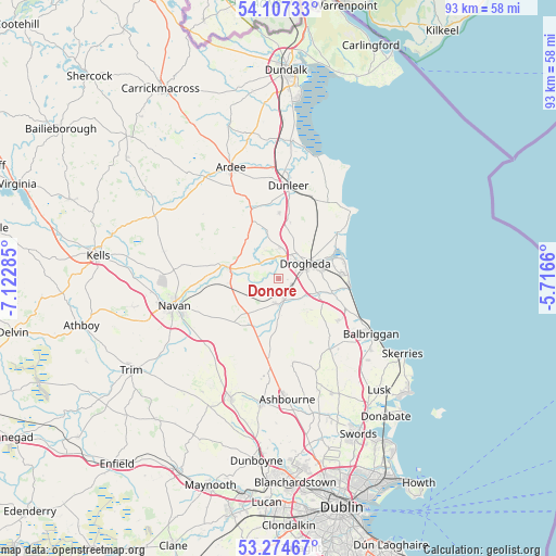
Donore GPS coordinates[2]
53° 41' 35.016" North, 6° 25' 10.992" West
| Map corner | latitude | longitude |
|---|---|---|
| Upper-left | 54.10733°, | -7.12285° |
| Center: | 53.69306°, | -6.41972° |
| Lower-right: | 53.27467°, | -5.7166° |
| Map W x H: | 92.6×92.6 km | = 57.5×57.5mi |
| max Lat: | 55.25° ⇑21.8% North |
| Donore: | 53.69306° |
| min Lat: | ⇓78.2% South 51.52487° |
| min Long | Donore | max Long |
| -10.26889° | -6.41972° | -6.04944° |
| W 77.2%⇐ | ⇒22.8% E |
Elevation
Elevation of Donore is 62 m = 203 ft, and this is 7.5 m = 25 ft above average elevation for this country.
| Max E: |
262 m = 860 ft | 37.4% |
| Donore | 62 m 203 ft | |
| Avg. | 54.5 m = 179 ft | |
Min E: |
0 m = 0 ft | 62.6% |
See also: Ireland elevation on elevation.city.
Geographical zone
Donore is located in North temperate zone (between Tropic of Cancer and the Arctic Circle). Distance of this North polar circle is 1431.1 km =889.2 mi to North.| Distance of | km | miles | from Donore |
|---|---|---|---|
| North Pole | 4037 | 2508.5 | to North |
| Arctic Circle | 1431.1 | 889.2 | to North |
| Tropic Cancer | 3364.2 | 2090.4 | to South |
| Equator | 5970.1 | 3709.6 | to South |


Nearby cities:
15 places around Donore: (largest is in red/bold)
• Balbriggan
18.2 km =11.3 mi,  121°
121°
• Balrothery
19.2 km =11.9 mi,  127°
127°
• Clogherhead
16.4 km =10.2 mi,  46°
46°
• Collon
10.7 km =6.6 mi,  335°
335°
• Drogheda
5.5 km =3.4 mi,  58°
58°
• Duleek
4 km =2.5 mi,  179°
179°
• Dunleer
15.9 km =9.9 mi,  5°
5°
• Julianstown
9.1 km =5.7 mi,  104°
104°
• Kentstown
10.1 km =6.3 mi,  224°
224°
• Laytown
12 km =7.5 mi, 95°
• Navan
17.8 km =11.1 mi,  255°
255°
• Slane
8.4 km =5.2 mi,  283°
283°
• Stamullin
12.3 km =7.6 mi, 125°
• Termonfeckin
12.7 km =7.9 mi, 51°
• Tullyallen
4.8 km =3 mi,  357°
357°
Sources, notices
• [Note1] Compared only with cities in Ireland existing in our database
• [Src1] Map data: © OpenStreetMap contributors (CC-BY-SA)
• [Src2] Other city data from geonames.org with taken over terms of usage.
• [Src3] Geographical zone / Annual Mean Temperature by Robert A. Rohde @ Wikipedia
