Killala geodata
Killala (Connaught) is a populated place; located in Ireland in Europe/Dublin (GMT+1) time zone. With population of 574 people, there are 492 cities with bigger population in this country. Compared to other cities in Ireland, 91.5% of cities are located further ↓South; 92.6% of cities are located further →East and 88% of cities have higher elevation than Killala. Note1


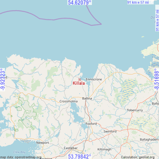
Killala GPS coordinates[2]
54° 12' 41.94" North, 9° 13' 12.36" West
| Map corner | latitude | longitude |
|---|---|---|
| Upper-left | 54.62079°, | -9.92323° |
| Center: | 54.21165°, | -9.2201° |
| Lower-right: | 53.79842°, | -8.51698° |
| Map W x H: | 91.4×91.4 km | = 56.8×56.8mi |
| max Lat: | 55.25° ⇑8.5% North |
| Killala: | 54.21165° |
| min Lat: | ⇓91.5% South 51.52487° |
| min Long | Killala | max Long |
| -10.26889° | -9.2201° | -6.04944° |
| W 7.4%⇐ | ⇒92.6% E |
Elevation
Elevation of Killala is 11 m = 36 ft, and this is 43.5 m = 143 ft below average elevation for this country.
| Max E: |
262 m = 860 ft | 88% |
| Avg. | 54.5 m = 179 ft | |
| Killala | 11 m = 36 ft | |
Min E: |
0 m = 0 ft | 12% |
See also: Ireland elevation on elevation.city.
Geographical zone
Killala is located in North temperate zone (between Tropic of Cancer and the Arctic Circle). Distance of this North polar circle is 1373.4 km =853.4 mi to North.| Distance of | km | miles | from Killala |
|---|---|---|---|
| North Pole | 3979.3 | 2472.6 | to North |
| Arctic Circle | 1373.4 | 853.4 | to North |
| Tropic Cancer | 3421.9 | 2126.3 | to South |
| Equator | 6027.8 | 3745.5 | to South |


Nearby cities:
15 places around Killala: (largest is in red/bold)
• Balla
45.8 km =28.5 mi,  172°
172°
• Ballina
11.1 km =6.9 mi,  161°
161°
• Castlebar
40.5 km =25.2 mi,  187°
187°
• Charlestown
39.1 km =24.3 mi,  134°
134°
• Coolaney
40.5 km =25.2 mi,  95°
95°
• Crossmolina
13.9 km =8.6 mi,  206°
206°
• Foxford
26.6 km =16.5 mi, 165°
• Inishcrone
8.3 km =5.2 mi,  86°
86°
• Kiltamagh
42.7 km =26.5 mi, 160°
• Knocknalower
39.3 km =24.4 mi,  274°
274°
• Newport
42.1 km =26.2 mi, 210°
• Rosses Point
43.8 km =27.2 mi,  75°
75°
• Strandhill
41.3 km =25.7 mi, 80°
• Swinford
34 km =21.1 mi,  148°
148°
• Tobercurry
36.5 km =22.7 mi,  119°
119°
Sources, notices
• [Note1] Compared only with cities in Ireland existing in our database
• [Src1] Map data: © OpenStreetMap contributors (CC-BY-SA)
• [Src2] Other city data from geonames.org with taken over terms of usage.
• [Src3] Geographical zone / Annual Mean Temperature by Robert A. Rohde @ Wikipedia
