Glasnevin geodata
Glasnevin (Leinster) is a populated place; located in Ireland in Europe/Dublin (GMT+1) time zone. With population of 3,633 people, there are 172 cities with bigger population in this country. Compared to other cities in Ireland, 63.6% of cities are located further ↓South; 84.6% of cities are located further ←West and 97.2% of cities have higher elevation than Glasnevin. Note1


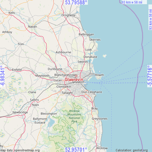
Glasnevin GPS coordinates[2]
53° 22' 42.636" North, 6° 16' 49.008" West
| Map corner | latitude | longitude |
|---|---|---|
| Upper-left | 53.79588°, | -6.98341° |
| Center: | 53.37851°, | -6.28028° |
| Lower-right: | 52.95701°, | -5.57716° |
| Map W x H: | 93.3×93.3 km | = 58×58mi |
| max Lat: | 55.25° ⇑36.4% North |
| Glasnevin: | 53.37851° |
| min Lat: | ⇓63.6% South 51.52487° |
| min Long | Glasnevin | max Long |
| -10.26889° | -6.28028° | -6.04944° |
| W 84.6%⇐ | ⇒15.4% E |
Elevation
Elevation of Glasnevin is 5 m = 16 ft, and this is 49.5 m = 162 ft below average elevation for this country.
| Max E: |
262 m = 860 ft | 97.2% |
| Avg. | 54.5 m = 179 ft | |
| Glasnevin | 5 m = 16 ft | |
Min E: |
0 m = 0 ft | 2.8% |
See also: Ireland elevation on elevation.city.
Geographical zone
Glasnevin is located in North temperate zone (between Tropic of Cancer and the Arctic Circle). Distance of this North polar circle is 1466 km =910.9 mi to North.| Distance of | km | miles | from Glasnevin |
|---|---|---|---|
| North Pole | 4071.9 | 2530.2 | to North |
| Arctic Circle | 1466 | 910.9 | to North |
| Tropic Cancer | 3329.2 | 2068.7 | to South |
| Equator | 5935.1 | 3687.9 | to South |


Nearby cities:
15 places around Glasnevin: (largest is in red/bold)
• Artane
4.5 km =2.8 mi,  77°
77°
• Ballymun
2.3 km =1.4 mi,  22°
22°
• Beaumont
3.7 km =2.3 mi,  74°
74°
• Bonnybrook
5.3 km =3.3 mi, 65°
• Cabra
1.6 km =1 mi,  216°
216°
• Chapelizod
5.3 km =3.3 mi,  231°
231°
• Coolock
5.4 km =3.4 mi, 77°
• Donnycarney
4.7 km =2.9 mi,  96°
96°
• Drumcondra
2 km =1.2 mi,  115°
115°
• Fairview
3 km =1.9 mi, 117°
• Finglas
1.6 km =1 mi,  317°
317°
• Greenhills
5.1 km =3.2 mi,  197°
197°
• Killester
5.1 km =3.2 mi, 96°
• Marino
3 km =1.9 mi,  107°
107°
• Rialto
4.8 km =3 mi,  193°
193°
Sources, notices
• [Note1] Compared only with cities in Ireland existing in our database
• [Src1] Map data: © OpenStreetMap contributors (CC-BY-SA)
• [Src2] Other city data from geonames.org with taken over terms of usage.
• [Src3] Geographical zone / Annual Mean Temperature by Robert A. Rohde @ Wikipedia
