Drumcondra geodata
Drumcondra (Leinster) is a populated place; located in Ireland in Europe/Dublin (GMT+0) time zone. With population of 4,465 people, there are 149 cities with bigger population in this country. Compared to other cities in Ireland, 62.8% of cities are located further ↓South; 86.5% of cities are located further ←West and 83.9% of cities have higher elevation than Drumcondra. Note1


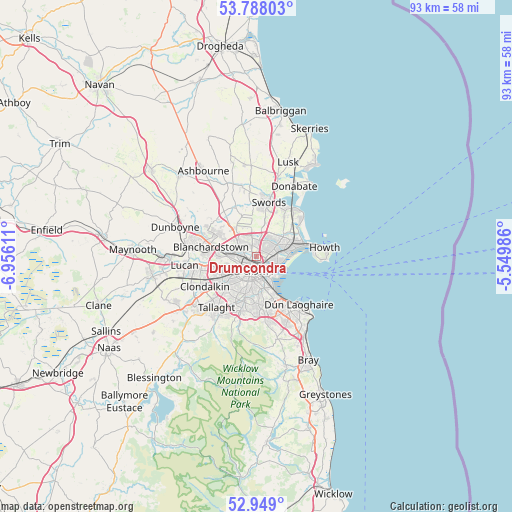
Drumcondra GPS coordinates[2]
53° 22' 14.088" North, 6° 15' 10.728" West
| Map corner | latitude | longitude |
|---|---|---|
| Upper-left | 53.78803°, | -6.95611° |
| Center: | 53.37058°, | -6.25298° |
| Lower-right: | 52.949°, | -5.54986° |
| Map W x H: | 93.3×93.3 km | = 58×58mi |
| max Lat: | 55.25° ⇑37.2% North |
| Drumcondra: | 53.37058° |
| min Lat: | ⇓62.8% South 51.52487° |
| min Long | Drumcondra | max Long |
| -10.26889° | -6.25298° | -6.04944° |
| W 86.5%⇐ | ⇒13.5% E |
Elevation
Elevation of Drumcondra is 14 m = 46 ft, and this is 40.5 m = 133 ft below average elevation for this country.
| Max E: |
262 m = 860 ft | 83.9% |
| Avg. | 54.5 m = 179 ft | |
| Drumcondra | 14 m = 46 ft | |
Min E: |
0 m = 0 ft | 16.1% |
See also: Ireland elevation on elevation.city.
Geographical zone
Drumcondra is located in North temperate zone (between Tropic of Cancer and the Arctic Circle). Distance of this North polar circle is 1466.9 km =911.5 mi to North.| Distance of | km | miles | from Drumcondra |
|---|---|---|---|
| North Pole | 4072.8 | 2530.7 | to North |
| Arctic Circle | 1466.9 | 911.5 | to North |
| Tropic Cancer | 3328.3 | 2068.1 | to South |
| Equator | 5934.3 | 3687.4 | to South |


Nearby cities:
15 places around Drumcondra: (largest is in red/bold)
• Artane
3.2 km =2 mi,  54°
54°
• Ballymun
3.2 km =2 mi,  343°
343°
• Beaumont
2.5 km =1.6 mi,  42°
42°
• Bonnybrook
4.3 km =2.7 mi, 44°
• Cabra
2.8 km =1.7 mi,  261°
261°
• Coolock
4.1 km =2.5 mi,  60°
60°
• Donnycarney
2.9 km =1.8 mi,  83°
83°
• Dublin
4.2 km =2.6 mi,  176°
176°
• Fairview
1 km =0.6 mi,  120°
120°
• Finglas
3.6 km =2.2 mi,  305°
305°
• Glasnevin
2 km =1.2 mi,  295°
295°
• Killester
3.2 km =2 mi, 84°
• Marino
1.1 km =0.7 mi,  92°
92°
• Rialto
4.8 km =3 mi,  217°
217°
• Ringsend
3.6 km =2.2 mi,  151°
151°
Sources, notices
• [Note1] Compared only with cities in Ireland existing in our database
• [Src1] Map data: © OpenStreetMap contributors (CC-BY-SA)
• [Src2] Other city data from geonames.org with taken over terms of usage.
• [Src3] Geographical zone / Annual Mean Temperature by Robert A. Rohde @ Wikipedia
