Bruree geodata
Bruree (Munster) is a populated place; located in Ireland in Europe/Dublin (GMT+1) time zone. With population of 541 people, there are 506 cities with bigger population in this country. Compared to other cities in Ireland, 81.6% of cities are located further ↑North; 80.6% of cities are located further →East and 61.3% of cities have lower elevation than Bruree. Note1


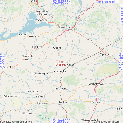
Bruree GPS coordinates[2]
52° 25' 18.984" North, 8° 39' 51.012" West
| Map corner | latitude | longitude |
|---|---|---|
| Upper-left | 52.84865°, | -9.3673° |
| Center: | 52.42194°, | -8.66417° |
| Lower-right: | 51.99106°, | -7.96105° |
| Map W x H: | 95.4×95.4 km | = 59.3×59.3mi |
| max Lat: | 55.25° ⇑81.6% North |
| Bruree: | 52.42194° |
| min Lat: | ⇓18.4% South 51.52487° |
| min Long | Bruree | max Long |
| -10.26889° | -8.66417° | -6.04944° |
| W 19.4%⇐ | ⇒80.6% E |
Elevation
Elevation of Bruree is 61 m = 200 ft, and this is 6.5 m = 21 ft above average elevation for this country.
| Max E: |
262 m = 860 ft | 38.7% |
| Bruree | 61 m 200 ft | |
| Avg. | 54.5 m = 179 ft | |
Min E: |
0 m = 0 ft | 61.3% |
See also: Ireland elevation on elevation.city.
Geographical zone
Bruree is located in North temperate zone (between Tropic of Cancer and the Arctic Circle). Distance of this North polar circle is 1572.4 km =977 mi to North.| Distance of | km | miles | from Bruree |
|---|---|---|---|
| North Pole | 4178.3 | 2596.3 | to North |
| Arctic Circle | 1572.4 | 977 | to North |
| Tropic Cancer | 3222.9 | 2002.6 | to South |
| Equator | 5828.8 | 3621.8 | to South |


Nearby cities:
15 places around Bruree: (largest is in red/bold)
• Adare
17.9 km =11.1 mi,  330°
330°
• Ballingarry
14.7 km =9.1 mi,  292°
292°
• Bruff
9.9 km =6.2 mi,  54°
54°
• Buttevant
21 km =13 mi,  180°
180°
• Caherconlish
23.2 km =14.4 mi,  34°
34°
• Churchtown
17.9 km =11.1 mi,  195°
195°
• Croom
11.4 km =7.1 mi,  341°
341°
• Doneraile
23.5 km =14.6 mi,  166°
166°
• Dromcollogher
18.9 km =11.7 mi,  241°
241°
• Hospital
16.8 km =10.4 mi,  70°
70°
• Kilfinnane
15 km =9.3 mi,  117°
117°
• Kilmallock
6.4 km =4 mi,  112°
112°
• Patrickswell
19.7 km =12.2 mi,  351°
351°
• Rathkeale
21.8 km =13.5 mi,  301°
301°
• Ráth Luirc
8.1 km =5 mi,  189°
189°
Sources, notices
• [Note1] Compared only with cities in Ireland existing in our database
• [Src1] Map data: © OpenStreetMap contributors (CC-BY-SA)
• [Src2] Other city data from geonames.org with taken over terms of usage.
• [Src3] Geographical zone / Annual Mean Temperature by Robert A. Rohde @ Wikipedia
