Ráth Luirc geodata
Ráth Luirc (Munster) is a populated place; located in Ireland in Europe/Dublin (GMT+1) time zone. With population of 3,672 people, there are 169 cities with bigger population in this country. Compared to other cities in Ireland, 84.1% of cities are located further ↑North; 81% of cities are located further →East and 91.3% of cities have lower elevation than Ráth Luirc. Note1


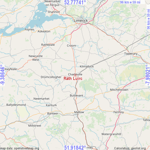
Ráth Luirc GPS coordinates[2]
52° 21' 0" North, 8° 40' 59.988" West
| Map corner | latitude | longitude |
|---|---|---|
| Upper-left | 52.77741°, | -9.38646° |
| Center: | 52.35°, | -8.68333° |
| Lower-right: | 51.91842°, | -7.98021° |
| Map W x H: | 95.5×95.5 km | = 59.3×59.3mi |
| max Lat: | 55.25° ⇑84.1% North |
| Ráth Luirc: | 52.35° |
| min Lat: | ⇓15.9% South 51.52487° |
| min Long | Ráth Luirc | max Long |
| -10.26889° | -8.68333° | -6.04944° |
| W 19%⇐ | ⇒81% E |
Elevation
Elevation of Ráth Luirc is 109 m = 358 ft, and this is 54.5 m = 179 ft above average elevation for this country.
| Max E: |
262 m = 860 ft | 8.7% |
| Ráth Luirc | 109 m 358 ft | |
| Avg. | 54.5 m = 179 ft | |
Min E: |
0 m = 0 ft | 91.3% |
See also: Ireland elevation on elevation.city.
Geographical zone
Ráth Luirc is located in North temperate zone (between Tropic of Cancer and the Arctic Circle). Distance of this North polar circle is 1580.4 km =982 mi to North.| Distance of | km | miles | from Ráth Luirc |
|---|---|---|---|
| North Pole | 4186.3 | 2601.2 | to North |
| Arctic Circle | 1580.4 | 982 | to North |
| Tropic Cancer | 3214.9 | 1997.6 | to South |
| Equator | 5820.8 | 3616.9 | to South |


Nearby cities:
15 places around Ráth Luirc: (largest is in red/bold)
• Adare
24.8 km =15.4 mi,  342°
342°
• Ballingarry
18.3 km =11.4 mi,  318°
318°
• Bruff
16.7 km =10.4 mi,  34°
34°
• Bruree
8.1 km =5 mi,  9°
9°
• Buttevant
13 km =8.1 mi,  175°
175°
• Churchtown
9.9 km =6.2 mi,  200°
200°
• Croom
19 km =11.8 mi,  352°
352°
• Doneraile
16.3 km =10.1 mi,  155°
155°
• Dromcollogher
15.3 km =9.5 mi,  265°
265°
• Hospital
21.9 km =13.6 mi,  51°
51°
• Kanturk
25.2 km =15.7 mi,  215°
215°
• Kilfinnane
14.6 km =9.1 mi,  86°
86°
• Kilmallock
9.1 km =5.7 mi, 52°
• Mallow
24.3 km =15.1 mi,  171°
171°
• Rathkeale
26 km =16.2 mi, 318°
Sources, notices
• [Note1] Compared only with cities in Ireland existing in our database
• [Src1] Map data: © OpenStreetMap contributors (CC-BY-SA)
• [Src2] Other city data from geonames.org with taken over terms of usage.
• [Src3] Geographical zone / Annual Mean Temperature by Robert A. Rohde @ Wikipedia
