Blanchardstown geodata
Blanchardstown (Leinster) is a populated place; located in Ireland in Europe/Dublin (GMT+1) time zone. With population of 16,511 people, there are 26 cities with bigger population in this country. Compared to other cities in Ireland, 64.9% of cities are located further ↓South; 79.9% of cities are located further ←West and 51.2% of cities have higher elevation than Blanchardstown. Note1


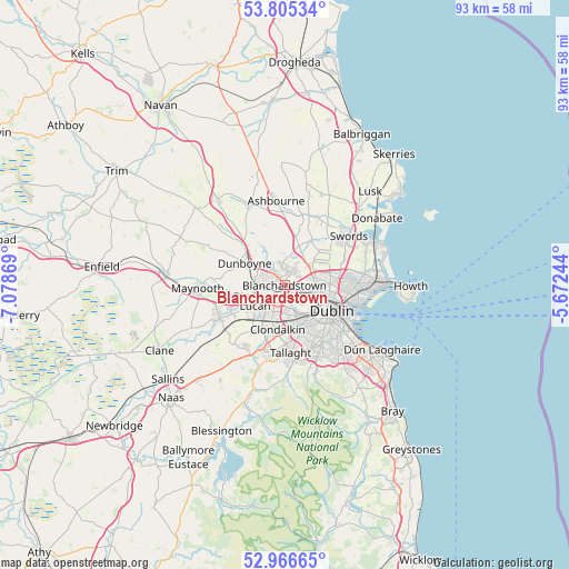
Blanchardstown GPS coordinates[2]
53° 23' 17.016" North, 6° 22' 32.016" West
| Map corner | latitude | longitude |
|---|---|---|
| Upper-left | 53.80534°, | -7.07869° |
| Center: | 53.38806°, | -6.37556° |
| Lower-right: | 52.96665°, | -5.67244° |
| Map W x H: | 93.3×93.3 km | = 58×58mi |
| max Lat: | 55.25° ⇑35.1% North |
| Blanchardstown: | 53.38806° |
| min Lat: | ⇓64.9% South 51.52487° |
| min Long | Blanchardstown | max Long |
| -10.26889° | -6.37556° | -6.04944° |
| W 79.9%⇐ | ⇒20.1% E |
Elevation
Elevation of Blanchardstown is 49 m = 161 ft, and this is 5.5 m = 18 ft below average elevation for this country.
| Max E: |
262 m = 860 ft | 51.2% |
| Avg. | 54.5 m = 179 ft | |
| Blanchardstown | 49 m = 161 ft | |
Min E: |
0 m = 0 ft | 48.8% |
See also: Ireland elevation on elevation.city.
Geographical zone
Blanchardstown is located in North temperate zone (between Tropic of Cancer and the Arctic Circle). Distance of this North polar circle is 1465 km =910.3 mi to North.| Distance of | km | miles | from Blanchardstown |
|---|---|---|---|
| North Pole | 4070.9 | 2529.5 | to North |
| Arctic Circle | 1465 | 910.3 | to North |
| Tropic Cancer | 3330.3 | 2069.4 | to South |
| Equator | 5936.2 | 3688.6 | to South |


Nearby cities:
15 places around Blanchardstown: (largest is in red/bold)
• Ballyfermot
5.2 km =3.2 mi,  164°
164°
• Ballymun
7.3 km =4.5 mi,  81°
81°
• Cabra
5.9 km =3.7 mi,  113°
113°
• Castleknock
1.7 km =1.1 mi,  151°
151°
• Chapelizod
4.9 km =3 mi, 153°
• Cherry Orchard
5.8 km =3.6 mi,  181°
181°
• Clondalkin
7.2 km =4.5 mi,  191°
191°
• Clonee
5.3 km =3.3 mi,  299°
299°
• Dunboyne
7.4 km =4.6 mi, 297°
• Finglas
5.2 km =3.2 mi,  88°
88°
• Glasnevin
6.4 km =4 mi,  99°
99°
• Greenhills
7.6 km =4.7 mi,  140°
140°
• Hartstown
3.5 km =2.2 mi,  279°
279°
• Lucan
5.9 km =3.7 mi,  234°
234°
• Palmerstown
4.2 km =2.6 mi, 182°
Sources, notices
• [Note1] Compared only with cities in Ireland existing in our database
• [Src1] Map data: © OpenStreetMap contributors (CC-BY-SA)
• [Src2] Other city data from geonames.org with taken over terms of usage.
• [Src3] Geographical zone / Annual Mean Temperature by Robert A. Rohde @ Wikipedia
