Clondalkin geodata
Clondalkin (Leinster) is a populated place; located in Ireland in Europe/Dublin (GMT+1) time zone. With population of 14,508 people, there are 35 cities with bigger population in this country. Compared to other cities in Ireland, 57.9% of cities are located further ↓South; 78.6% of cities are located further ←West and 59.8% of cities have lower elevation than Clondalkin. Note1


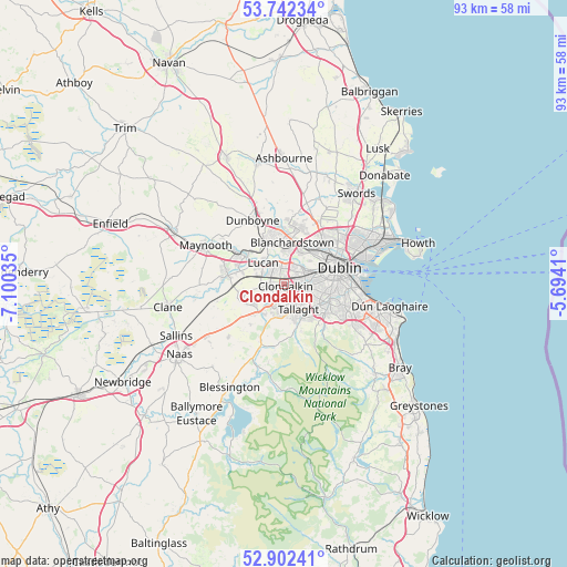
Clondalkin GPS coordinates[2]
53° 19' 27.984" North, 6° 23' 49.992" West
| Map corner | latitude | longitude |
|---|---|---|
| Upper-left | 53.74234°, | -7.10035° |
| Center: | 53.32444°, | -6.39722° |
| Lower-right: | 52.90241°, | -5.6941° |
| Map W x H: | 93.4×93.4 km | = 58×58mi |
| max Lat: | 55.25° ⇑42.1% North |
| Clondalkin: | 53.32444° |
| min Lat: | ⇓57.9% South 51.52487° |
| min Long | Clondalkin | max Long |
| -10.26889° | -6.39722° | -6.04944° |
| W 78.6%⇐ | ⇒21.4% E |
Elevation
Elevation of Clondalkin is 60 m = 197 ft, and this is 5.5 m = 18 ft above average elevation for this country.
| Max E: |
262 m = 860 ft | 40.2% |
| Clondalkin | 60 m 197 ft | |
| Avg. | 54.5 m = 179 ft | |
Min E: |
0 m = 0 ft | 59.8% |
See also: Ireland elevation on elevation.city.
Geographical zone
Clondalkin is located in North temperate zone (between Tropic of Cancer and the Arctic Circle). Distance of this North polar circle is 1472.1 km =914.7 mi to North.| Distance of | km | miles | from Clondalkin |
|---|---|---|---|
| North Pole | 4077.9 | 2533.9 | to North |
| Arctic Circle | 1472.1 | 914.7 | to North |
| Tropic Cancer | 3323.2 | 2064.9 | to South |
| Equator | 5929.1 | 3684.2 | to South |


Nearby cities:
15 places around Clondalkin: (largest is in red/bold)
• Ballyfermot
3.5 km =2.2 mi,  54°
54°
• Castleknock
6 km =3.7 mi,  21°
21°
• Chapelizod
4.5 km =2.8 mi, 53°
• Cherry Orchard
1.8 km =1.1 mi,  44°
44°
• Crumlin
5.5 km =3.4 mi,  93°
93°
• Firhouse
6.1 km =3.8 mi,  140°
140°
• Greenhills
6.4 km =4 mi,  79°
79°
• Jobstown
5.1 km =3.2 mi,  188°
188°
• Knocklyon
6.6 km =4.1 mi, 138°
• Lucan
5 km =3.1 mi,  317°
317°
• Oldbawn
5.8 km =3.6 mi,  160°
160°
• Palmerstown
3.1 km =1.9 mi, 24°
• Saggart
5.8 km =3.6 mi,  212°
212°
• Tallaght
4.6 km =2.9 mi, 159°
• Templeogue
6.7 km =4.2 mi,  118°
118°
Sources, notices
• [Note1] Compared only with cities in Ireland existing in our database
• [Src1] Map data: © OpenStreetMap contributors (CC-BY-SA)
• [Src2] Other city data from geonames.org with taken over terms of usage.
• [Src3] Geographical zone / Annual Mean Temperature by Robert A. Rohde @ Wikipedia
