Baltinglass geodata
Baltinglass (Leinster) is a populated place; located in Ireland in Europe/Dublin (GMT+1) time zone. With population of 2,061 people, there are 227 cities with bigger population in this country. Compared to other cities in Ireland, 63.6% of cities are located further ↑North; 68.3% of cities are located further ←West and 95.3% of cities have lower elevation than Baltinglass. Note1


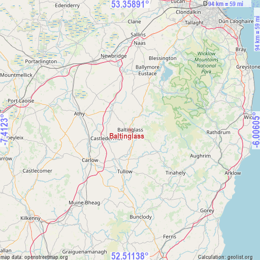
Baltinglass GPS coordinates[2]
52° 56' 13.992" North, 6° 42' 33.012" West
| Map corner | latitude | longitude |
|---|---|---|
| Upper-left | 53.35891°, | -7.4123° |
| Center: | 52.93722°, | -6.70917° |
| Lower-right: | 52.51138°, | -6.00605° |
| Map W x H: | 94.2×94.2 km | = 58.5×58.5mi |
| max Lat: | 55.25° ⇑63.6% North |
| Baltinglass: | 52.93722° |
| min Lat: | ⇓36.4% South 51.52487° |
| min Long | Baltinglass | max Long |
| -10.26889° | -6.70917° | -6.04944° |
| W 68.3%⇐ | ⇒31.7% E |
Elevation
Elevation of Baltinglass is 128 m = 420 ft, and this is 73.5 m = 241 ft above average elevation for this country.
| Max E: |
262 m = 860 ft | 4.7% |
| Baltinglass | 128 m 420 ft | |
| Avg. | 54.5 m = 179 ft | |
Min E: |
0 m = 0 ft | 95.3% |
See also: Ireland elevation on elevation.city.
Geographical zone
Baltinglass is located in North temperate zone (between Tropic of Cancer and the Arctic Circle). Distance of this North polar circle is 1515.1 km =941.4 mi to North.| Distance of | km | miles | from Baltinglass |
|---|---|---|---|
| North Pole | 4121 | 2560.7 | to North |
| Arctic Circle | 1515.1 | 941.4 | to North |
| Tropic Cancer | 3280.1 | 2038.2 | to South |
| Equator | 5886.1 | 3657.5 | to South |


Nearby cities:
15 places around Baltinglass: (largest is in red/bold)
• Athy
19.1 km =11.9 mi,  288°
288°
• Ballitore
10.7 km =6.6 mi,  316°
316°
• Ballon
22.2 km =13.8 mi,  190°
190°
• Calverstown
17.2 km =10.7 mi,  339°
339°
• Carlow
18.1 km =11.2 mi,  233°
233°
• Castledermot
9.5 km =5.9 mi,  250°
250°
• Dunlavin
13.2 km =8.2 mi,  1°
1°
• Hacketstown
13.1 km =8.1 mi,  128°
128°
• Kilcullen
21.6 km =13.4 mi,  353°
353°
• Moone
8.3 km =5.2 mi,  301°
301°
• Old Kilcullen
19.2 km =11.9 mi, 348°
• Rathvilly
6.6 km =4.1 mi,  170°
170°
• Suncroft
21.2 km =13.2 mi,  331°
331°
• Tullow
15.3 km =9.5 mi, 186°
• Valleymount
21.3 km =13.2 mi,  29°
29°
Sources, notices
• [Note1] Compared only with cities in Ireland existing in our database
• [Src1] Map data: © OpenStreetMap contributors (CC-BY-SA)
• [Src2] Other city data from geonames.org with taken over terms of usage.
• [Src3] Geographical zone / Annual Mean Temperature by Robert A. Rohde @ Wikipedia
