Carlow geodata
Carlow (Leinster) is a seat of a second-order administrative division; located in Ireland in Europe/Dublin (GMT+1) time zone. With population of 20,055 people, there are 18 cities with bigger population in this country. Compared to other cities in Ireland, 66.8% of cities are located further ↑North; 61.7% of cities are located further ←West and 54.1% of cities have lower elevation than Carlow. Note1


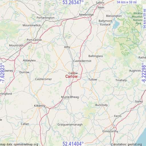
Carlow GPS coordinates[2]
52° 50' 26.988" North, 6° 55' 33.996" West
| Map corner | latitude | longitude |
|---|---|---|
| Upper-left | 53.26347°, | -7.62923° |
| Center: | 52.84083°, | -6.92611° |
| Lower-right: | 52.41404°, | -6.22298° |
| Map W x H: | 94.4×94.4 km | = 58.7×58.7mi |
| max Lat: | 55.25° ⇑66.8% North |
| Carlow: | 52.84083° |
| min Lat: | ⇓33.2% South 51.52487° |
| min Long | Carlow | max Long |
| -10.26889° | -6.92611° | -6.04944° |
| W 61.7%⇐ | ⇒38.3% E |
Elevation
Elevation of Carlow is 55 m = 180 ft, and this is 0.5 m = 2 ft above average elevation for this country.
| Max E: |
262 m = 860 ft | 45.9% |
| Carlow | 55 m 180 ft | |
| Avg. | 54.5 m = 179 ft | |
Min E: |
0 m = 0 ft | 54.1% |
See also: Ireland elevation on elevation.city.
Geographical zone
Carlow is located in North temperate zone (between Tropic of Cancer and the Arctic Circle). Distance of this North polar circle is 1525.8 km =948.1 mi to North.| Distance of | km | miles | from Carlow |
|---|---|---|---|
| North Pole | 4131.7 | 2567.3 | to North |
| Arctic Circle | 1525.8 | 948.1 | to North |
| Tropic Cancer | 3269.4 | 2031.5 | to South |
| Equator | 5875.3 | 3650.7 | to South |


Nearby cities:
15 places around Carlow: (largest is in red/bold)
• Athy
17.1 km =10.6 mi,  347°
347°
• Bagenalstown
15.8 km =9.8 mi,  188°
188°
• Ballitore
19.8 km =12.3 mi,  21°
21°
• Ballon
15.4 km =9.6 mi,  136°
136°
• Ballylinan
13.9 km =8.6 mi,  326°
326°
• Baltinglass
18.1 km =11.2 mi,  53°
53°
• Castlecomer
19.5 km =12.1 mi,  258°
258°
• Castledermot
9.4 km =5.8 mi,  36°
36°
• Leighlinbridge
12 km =7.5 mi,  195°
195°
• Moneenroe
15.4 km =9.6 mi,  269°
269°
• Moone
16.7 km =10.4 mi,  26°
26°
• Paulstown
18.9 km =11.7 mi, 200°
• Rathvilly
16.2 km =10.1 mi,  74°
74°
• Stradbally
24.7 km =15.3 mi,  321°
321°
• Tullow
13.5 km =8.4 mi,  109°
109°
Sources, notices
• [Note1] Compared only with cities in Ireland existing in our database
• [Src1] Map data: © OpenStreetMap contributors (CC-BY-SA)
• [Src2] Other city data from geonames.org with taken over terms of usage.
• [Src3] Geographical zone / Annual Mean Temperature by Robert A. Rohde @ Wikipedia
