Hacketstown geodata
Hacketstown (Leinster) is a populated place; located in Ireland in Europe/Dublin (GMT+1) time zone. With population of 600 people, there are 480 cities with bigger population in this country. Compared to other cities in Ireland, 65.3% of cities are located further ↑North; 71.7% of cities are located further ←West and 99.1% of cities have lower elevation than Hacketstown. Note1


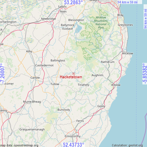
Hacketstown GPS coordinates[2]
52° 51' 50.004" North, 6° 33' 24.984" West
| Map corner | latitude | longitude |
|---|---|---|
| Upper-left | 53.2863°, | -7.26007° |
| Center: | 52.86389°, | -6.55694° |
| Lower-right: | 52.43733°, | -5.85382° |
| Map W x H: | 94.4×94.4 km | = 58.7×58.7mi |
| max Lat: | 55.25° ⇑65.3% North |
| Hacketstown: | 52.86389° |
| min Lat: | ⇓34.7% South 51.52487° |
| min Long | Hacketstown | max Long |
| -10.26889° | -6.55694° | -6.04944° |
| W 71.7%⇐ | ⇒28.3% E |
Elevation
Elevation of Hacketstown is 179 m = 587 ft, and this is 124.5 m = 408 ft above average elevation for this country.
| Max E: |
262 m = 860 ft | 0.90000000000001% |
| Hacketstown | 179 m 587 ft | |
| Avg. | 54.5 m = 179 ft | |
Min E: |
0 m = 0 ft | 99.1% |
See also: Ireland elevation on elevation.city.
Geographical zone
Hacketstown is located in North temperate zone (between Tropic of Cancer and the Arctic Circle). Distance of this North polar circle is 1523.3 km =946.5 mi to North.| Distance of | km | miles | from Hacketstown |
|---|---|---|---|
| North Pole | 4129.1 | 2565.7 | to North |
| Arctic Circle | 1523.3 | 946.5 | to North |
| Tropic Cancer | 3272 | 2033.1 | to South |
| Equator | 5877.9 | 3652.4 | to South |


Nearby cities:
15 places around Hacketstown: (largest is in red/bold)
• Aughrim
15.4 km =9.6 mi,  94°
94°
• Avoca
22.9 km =14.2 mi, 93°
• Ballitore
23.7 km =14.7 mi,  312°
312°
• Ballon
19.7 km =12.2 mi,  225°
225°
• Baltinglass
13.1 km =8.1 mi, 308°
• Bunclody
24.1 km =15 mi,  195°
195°
• Carnew
17.8 km =11.1 mi,  166°
166°
• Castledermot
19.8 km =12.3 mi,  284°
284°
• Dunlavin
23.5 km =14.6 mi,  335°
335°
• Moone
21.3 km =13.2 mi, 305°
• Mucklagh
12.4 km =7.7 mi,  117°
117°
• Rathdrum
22.6 km =14 mi,  72°
72°
• Rathvilly
9.3 km =5.8 mi, 280°
• Tinahely
9.8 km =6.1 mi,  139°
139°
• Tullow
14 km =8.7 mi,  239°
239°
Sources, notices
• [Note1] Compared only with cities in Ireland existing in our database
• [Src1] Map data: © OpenStreetMap contributors (CC-BY-SA)
• [Src2] Other city data from geonames.org with taken over terms of usage.
• [Src3] Geographical zone / Annual Mean Temperature by Robert A. Rohde @ Wikipedia
