Ballycanew geodata
Ballycanew (Leinster) is a populated place; located in Ireland in Europe/Dublin (GMT+1) time zone. With population of 502 people, there are 525 cities with bigger population in this country. Compared to other cities in Ireland, 75.7% of cities are located further ↑North; 82.9% of cities are located further ←West and 68.7% of cities have higher elevation than Ballycanew. Note1


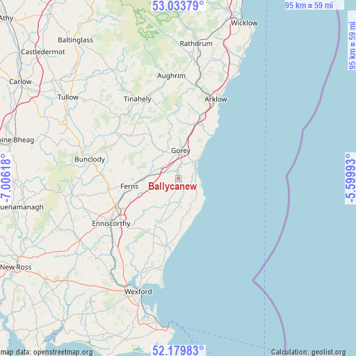
Ballycanew GPS coordinates[2]
52° 36' 32.004" North, 6° 18' 11.016" West
| Map corner | latitude | longitude |
|---|---|---|
| Upper-left | 53.03379°, | -7.00618° |
| Center: | 52.60889°, | -6.30306° |
| Lower-right: | 52.17983°, | -5.59993° |
| Map W x H: | 95×94.9 km | = 59×59mi |
| max Lat: | 55.25° ⇑75.7% North |
| Ballycanew: | 52.60889° |
| min Lat: | ⇓24.3% South 51.52487° |
| min Long | Ballycanew | max Long |
| -10.26889° | -6.30306° | -6.04944° |
| W 82.9%⇐ | ⇒17.1% E |
Elevation
Elevation of Ballycanew is 27 m = 89 ft, and this is 27.5 m = 90 ft below average elevation for this country.
| Max E: |
262 m = 860 ft | 68.7% |
| Avg. | 54.5 m = 179 ft | |
| Ballycanew | 27 m = 89 ft | |
Min E: |
0 m = 0 ft | 31.3% |
See also: Ireland elevation on elevation.city.
Geographical zone
Ballycanew is located in North temperate zone (between Tropic of Cancer and the Arctic Circle). Distance of this North polar circle is 1551.6 km =964.1 mi to North.| Distance of | km | miles | from Ballycanew |
|---|---|---|---|
| North Pole | 4157.5 | 2583.3 | to North |
| Arctic Circle | 1551.6 | 964.1 | to North |
| Tropic Cancer | 3243.6 | 2015.5 | to South |
| Equator | 5849.6 | 3634.8 | to South |


Nearby cities:
15 places around Ballycanew: (largest is in red/bold)
• Arklow
23.2 km =14.4 mi,  28°
28°
• Aughrim
27.2 km =16.9 mi,  356°
356°
• Avoca
27.7 km =17.2 mi,  12°
12°
• Ballinroad
12.3 km =7.6 mi,  214°
214°
• Bunclody
24.2 km =15 mi,  282°
282°
• Carnew
17 km =10.6 mi,  310°
310°
• Castlebridge
26.7 km =16.6 mi,  201°
201°
• Castletown
14.8 km =9.2 mi, 31°
• Courtown
6.4 km =4 mi,  51°
51°
• Enniscorthy
21 km =13 mi,  235°
235°
• Ferns
13.5 km =8.4 mi,  260°
260°
• Ford
10.9 km =6.8 mi,  171°
171°
• Gorey
7.4 km =4.6 mi, 5°
• Mucklagh
23.5 km =14.6 mi,  345°
345°
• Tinahely
23.5 km =14.6 mi,  332°
332°
Sources, notices
• [Note1] Compared only with cities in Ireland existing in our database
• [Src1] Map data: © OpenStreetMap contributors (CC-BY-SA)
• [Src2] Other city data from geonames.org with taken over terms of usage.
• [Src3] Geographical zone / Annual Mean Temperature by Robert A. Rohde @ Wikipedia
