Bunclody geodata
Bunclody (Leinster) is a populated place; located in Ireland in Europe/Dublin (GMT+1) time zone. With population of 2,012 people, there are 229 cities with bigger population in this country. Compared to other cities in Ireland, 73.8% of cities are located further ↑North; 70% of cities are located further ←West and 62.2% of cities have higher elevation than Bunclody. Note1


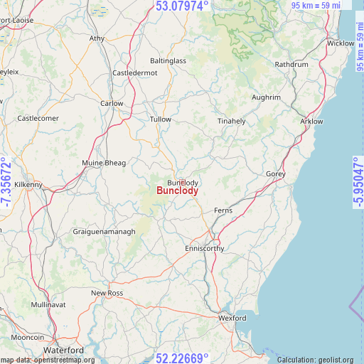
Bunclody GPS coordinates[2]
52° 39' 19.08" North, 6° 39' 12.924" West
| Map corner | latitude | longitude |
|---|---|---|
| Upper-left | 53.07974°, | -7.35672° |
| Center: | 52.6553°, | -6.65359° |
| Lower-right: | 52.22669°, | -5.95047° |
| Map W x H: | 94.9×94.8 km | = 59×58.9mi |
| max Lat: | 55.25° ⇑73.8% North |
| Bunclody: | 52.6553° |
| min Lat: | ⇓26.2% South 51.52487° |
| min Long | Bunclody | max Long |
| -10.26889° | -6.65359° | -6.04944° |
| W 70%⇐ | ⇒30% E |
Elevation
Elevation of Bunclody is 35 m = 115 ft, and this is 19.5 m = 64 ft below average elevation for this country.
| Max E: |
262 m = 860 ft | 62.2% |
| Avg. | 54.5 m = 179 ft | |
| Bunclody | 35 m = 115 ft | |
Min E: |
0 m = 0 ft | 37.8% |
See also: Ireland elevation on elevation.city.
Geographical zone
Bunclody is located in North temperate zone (between Tropic of Cancer and the Arctic Circle). Distance of this North polar circle is 1546.5 km =961 mi to North.| Distance of | km | miles | from Bunclody |
|---|---|---|---|
| North Pole | 4152.3 | 2580.1 | to North |
| Arctic Circle | 1546.5 | 961 | to North |
| Tropic Cancer | 3248.8 | 2018.7 | to South |
| Equator | 5854.7 | 3637.9 | to South |


Nearby cities:
15 places around Bunclody: (largest is in red/bold)
• Bagenalstown
21.4 km =13.3 mi,  283°
283°
• Ballinroad
22.6 km =14 mi,  132°
132°
• Ballon
12.2 km =7.6 mi,  320°
320°
• Ballycanew
24.2 km =15 mi,  102°
102°
• Borris
18.8 km =11.7 mi,  250°
250°
• Carnew
12.2 km =7.6 mi,  61°
61°
• Enniscorthy
18.4 km =11.4 mi,  159°
159°
• Ferns
12.8 km =8 mi, 125°
• Gorey
24.4 km =15.2 mi,  84°
84°
• Graiguenamanagh
24 km =14.9 mi,  237°
237°
• Hacketstown
24.1 km =15 mi,  15°
15°
• Leighlinbridge
23.3 km =14.5 mi,  292°
292°
• Mucklagh
24.8 km =15.4 mi,  44°
44°
• Tinahely
20.3 km =12.6 mi, 39°
• Tullow
17.1 km =10.6 mi,  340°
340°
Sources, notices
• [Note1] Compared only with cities in Ireland existing in our database
• [Src1] Map data: © OpenStreetMap contributors (CC-BY-SA)
• [Src2] Other city data from geonames.org with taken over terms of usage.
• [Src3] Geographical zone / Annual Mean Temperature by Robert A. Rohde @ Wikipedia
