Mucklagh geodata
Mucklagh (Leinster) is a populated place; located in Ireland in Europe/Dublin (GMT+1) time zone. With population of 810 people, there are 398 cities with bigger population in this country. Compared to other cities in Ireland, 67.4% of cities are located further ↑North; 78.9% of cities are located further ←West and 96.4% of cities have lower elevation than Mucklagh. Note1


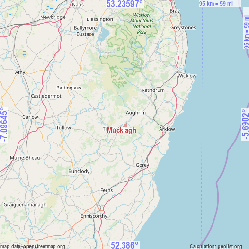
Mucklagh GPS coordinates[2]
52° 48' 47.016" North, 6° 23' 35.988" West
| Map corner | latitude | longitude |
|---|---|---|
| Upper-left | 53.23597°, | -7.09645° |
| Center: | 52.81306°, | -6.39333° |
| Lower-right: | 52.386°, | -5.6902° |
| Map W x H: | 94.5×94.5 km | = 58.7×58.7mi |
| max Lat: | 55.25° ⇑67.4% North |
| Mucklagh: | 52.81306° |
| min Lat: | ⇓32.6% South 51.52487° |
| min Long | Mucklagh | max Long |
| -10.26889° | -6.39333° | -6.04944° |
| W 78.9%⇐ | ⇒21.1% E |
Elevation
Elevation of Mucklagh is 136 m = 446 ft, and this is 81.5 m = 267 ft above average elevation for this country.
| Max E: |
262 m = 860 ft | 3.6% |
| Mucklagh | 136 m 446 ft | |
| Avg. | 54.5 m = 179 ft | |
Min E: |
0 m = 0 ft | 96.4% |
See also: Ireland elevation on elevation.city.
Geographical zone
Mucklagh is located in North temperate zone (between Tropic of Cancer and the Arctic Circle). Distance of this North polar circle is 1528.9 km =950 mi to North.| Distance of | km | miles | from Mucklagh |
|---|---|---|---|
| North Pole | 4134.8 | 2569.2 | to North |
| Arctic Circle | 1528.9 | 950 | to North |
| Tropic Cancer | 3266.3 | 2029.6 | to South |
| Equator | 5872.3 | 3648.9 | to South |


Nearby cities:
15 places around Mucklagh: (largest is in red/bold)
• Arklow
17.1 km =10.6 mi,  97°
97°
• Aughrim
6.3 km =3.9 mi,  44°
44°
• Avoca
12.6 km =7.8 mi,  69°
69°
• Ballycanew
23.5 km =14.6 mi,  165°
165°
• Bunclody
24.8 km =15.4 mi,  224°
224°
• Carnew
13.5 km =8.4 mi,  210°
210°
• Castletown
17 km =10.6 mi,  126°
126°
• Courtown
21.8 km =13.5 mi,  149°
149°
• Glenealy
22.9 km =14.2 mi, 43°
• Gorey
16.8 km =10.4 mi,  156°
156°
• Hacketstown
12.4 km =7.7 mi,  297°
297°
• Rathdrum
16.5 km =10.3 mi, 40°
• Rathvilly
21.4 km =13.3 mi,  289°
289°
• Tinahely
5 km =3.1 mi,  248°
248°
• Tullow
23.1 km =14.4 mi,  266°
266°
Sources, notices
• [Note1] Compared only with cities in Ireland existing in our database
• [Src1] Map data: © OpenStreetMap contributors (CC-BY-SA)
• [Src2] Other city data from geonames.org with taken over terms of usage.
• [Src3] Geographical zone / Annual Mean Temperature by Robert A. Rohde @ Wikipedia
