Tinahely geodata
Tinahely (Leinster) is a populated place; located in Ireland in Europe/Dublin (GMT+1) time zone. With population of 970 people, there are 355 cities with bigger population in this country. Compared to other cities in Ireland, 68.5% of cities are located further ↑North; 75.5% of cities are located further ←West and 84.6% of cities have lower elevation than Tinahely. Note1


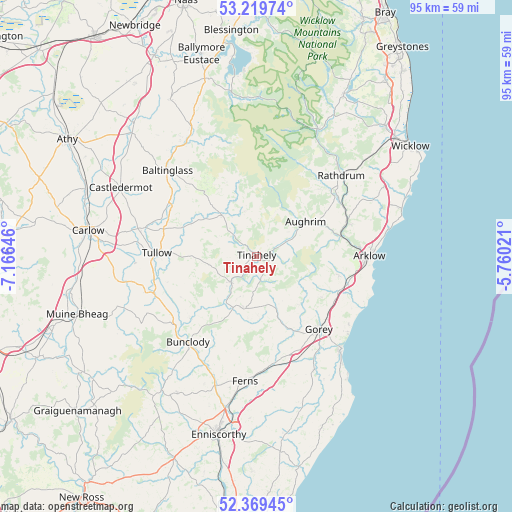
Tinahely GPS coordinates[2]
52° 47' 48.012" North, 6° 27' 47.988" West
| Map corner | latitude | longitude |
|---|---|---|
| Upper-left | 53.21974°, | -7.16646° |
| Center: | 52.79667°, | -6.46333° |
| Lower-right: | 52.36945°, | -5.76021° |
| Map W x H: | 94.5×94.5 km | = 58.7×58.7mi |
| max Lat: | 55.25° ⇑68.5% North |
| Tinahely: | 52.79667° |
| min Lat: | ⇓31.5% South 51.52487° |
| min Long | Tinahely | max Long |
| -10.26889° | -6.46333° | -6.04944° |
| W 75.5%⇐ | ⇒24.5% E |
Elevation
Elevation of Tinahely is 95 m = 312 ft, and this is 40.5 m = 133 ft above average elevation for this country.
| Max E: |
262 m = 860 ft | 15.4% |
| Tinahely | 95 m 312 ft | |
| Avg. | 54.5 m = 179 ft | |
Min E: |
0 m = 0 ft | 84.6% |
See also: Ireland elevation on elevation.city.
Geographical zone
Tinahely is located in North temperate zone (between Tropic of Cancer and the Arctic Circle). Distance of this North polar circle is 1530.7 km =951.1 mi to North.| Distance of | km | miles | from Tinahely |
|---|---|---|---|
| North Pole | 4136.6 | 2570.4 | to North |
| Arctic Circle | 1530.7 | 951.1 | to North |
| Tropic Cancer | 3264.5 | 2028.5 | to South |
| Equator | 5870.4 | 3647.7 | to South |


Nearby cities:
15 places around Tinahely: (largest is in red/bold)
• Arklow
21.6 km =13.4 mi,  91°
91°
• Aughrim
11.1 km =6.9 mi,  55°
55°
• Avoca
17.7 km =11 mi,  69°
69°
• Ballon
21.4 km =13.3 mi,  253°
253°
• Baltinglass
22.7 km =14.1 mi,  313°
313°
• Bunclody
20.3 km =12.6 mi,  219°
219°
• Carnew
10.1 km =6.3 mi,  191°
191°
• Castletown
20.2 km =12.6 mi,  113°
113°
• Courtown
23.2 km =14.4 mi,  137°
137°
• Gorey
17.8 km =11.1 mi, 139°
• Hacketstown
9.8 km =6.1 mi,  319°
319°
• Mucklagh
5 km =3.1 mi, 68°
• Rathdrum
21 km =13 mi,  46°
46°
• Rathvilly
18 km =11.2 mi,  300°
300°
• Tullow
18.4 km =11.4 mi,  271°
271°
Sources, notices
• [Note1] Compared only with cities in Ireland existing in our database
• [Src1] Map data: © OpenStreetMap contributors (CC-BY-SA)
• [Src2] Other city data from geonames.org with taken over terms of usage.
• [Src3] Geographical zone / Annual Mean Temperature by Robert A. Rohde @ Wikipedia
