Bagenalstown geodata
Bagenalstown (Leinster) is a populated place; located in Ireland in Europe/Dublin (GMT+1) time zone. With population of 3,033 people, there are 185 cities with bigger population in this country. Compared to other cities in Ireland, 72.1% of cities are located further ↑North; 60.3% of cities are located further ←West and 51.2% of cities have higher elevation than Bagenalstown. Note1


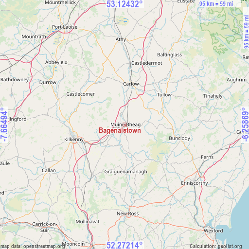
Bagenalstown GPS coordinates[2]
52° 42' 1.116" North, 6° 57' 42.516" West
| Map corner | latitude | longitude |
|---|---|---|
| Upper-left | 53.12432°, | -7.66494° |
| Center: | 52.70031°, | -6.96181° |
| Lower-right: | 52.27214°, | -6.25869° |
| Map W x H: | 94.8×94.8 km | = 58.9×58.9mi |
| max Lat: | 55.25° ⇑72.1% North |
| Bagenalstown: | 52.70031° |
| min Lat: | ⇓27.9% South 51.52487° |
| min Long | Bagenalstown | max Long |
| -10.26889° | -6.96181° | -6.04944° |
| W 60.3%⇐ | ⇒39.7% E |
Elevation
Elevation of Bagenalstown is 49 m = 161 ft, and this is 5.5 m = 18 ft below average elevation for this country.
| Max E: |
262 m = 860 ft | 51.2% |
| Avg. | 54.5 m = 179 ft | |
| Bagenalstown | 49 m = 161 ft | |
Min E: |
0 m = 0 ft | 48.8% |
See also: Ireland elevation on elevation.city.
Geographical zone
Bagenalstown is located in North temperate zone (between Tropic of Cancer and the Arctic Circle). Distance of this North polar circle is 1541.4 km =957.8 mi to North.| Distance of | km | miles | from Bagenalstown |
|---|---|---|---|
| North Pole | 4147.3 | 2577 | to North |
| Arctic Circle | 1541.4 | 957.8 | to North |
| Tropic Cancer | 3253.8 | 2021.8 | to South |
| Equator | 5859.7 | 3641 | to South |


Nearby cities:
15 places around Bagenalstown: (largest is in red/bold)
• Ballon
13.8 km =8.6 mi,  71°
71°
• Bennettsbridge
19 km =11.8 mi,  230°
230°
• Borris
11.5 km =7.1 mi,  164°
164°
• Bunclody
21.4 km =13.3 mi,  103°
103°
• Carlow
15.8 km =9.8 mi,  8°
8°
• Castlecomer
20.5 km =12.7 mi,  305°
305°
• Castledermot
24.5 km =15.2 mi,  19°
19°
• Gowran
10.9 km =6.8 mi,  223°
223°
• Graiguenamanagh
17.8 km =11.1 mi,  178°
178°
• Kilkenny
20.2 km =12.6 mi,  255°
255°
• Leighlinbridge
4.1 km =2.5 mi,  349°
349°
• Moneenroe
20.3 km =12.6 mi,  320°
320°
• Paulstown
4.6 km =2.9 mi,  242°
242°
• Thomastown
22.6 km =14 mi,  211°
211°
• Tullow
18.8 km =11.7 mi,  53°
53°
Sources, notices
• [Note1] Compared only with cities in Ireland existing in our database
• [Src1] Map data: © OpenStreetMap contributors (CC-BY-SA)
• [Src2] Other city data from geonames.org with taken over terms of usage.
• [Src3] Geographical zone / Annual Mean Temperature by Robert A. Rohde @ Wikipedia
