Bennettsbridge geodata
Bennettsbridge (Leinster) is a populated place; located in Ireland in Europe/Dublin (GMT+1) time zone. With population of 729 people, there are 424 cities with bigger population in this country. Compared to other cities in Ireland, 76.9% of cities are located further ↑North; 54.6% of cities are located further ←West and 57.5% of cities have higher elevation than Bennettsbridge. Note1


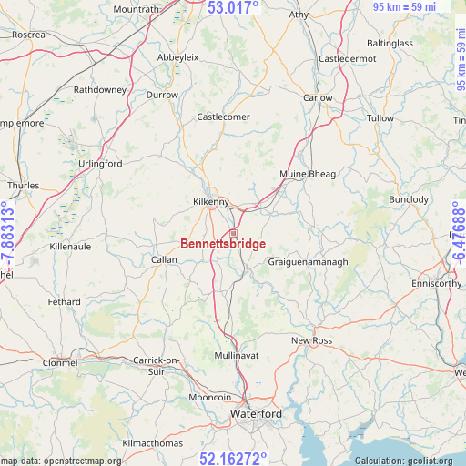
Bennettsbridge GPS coordinates[2]
52° 35' 30.984" North, 7° 10' 48" West
| Map corner | latitude | longitude |
|---|---|---|
| Upper-left | 53.017°, | -7.88313° |
| Center: | 52.59194°, | -7.18° |
| Lower-right: | 52.16272°, | -6.47688° |
| Map W x H: | 95×95 km | = 59×59mi |
| max Lat: | 55.25° ⇑76.9% North |
| Bennettsbridge: | 52.59194° |
| min Lat: | ⇓23.1% South 51.52487° |
| min Long | Bennettsbridge | max Long |
| -10.26889° | -7.18° | -6.04944° |
| W 54.6%⇐ | ⇒45.4% E |
Elevation
Elevation of Bennettsbridge is 41 m = 135 ft, and this is 13.5 m = 44 ft below average elevation for this country.
| Max E: |
262 m = 860 ft | 57.5% |
| Avg. | 54.5 m = 179 ft | |
| Bennettsbridge | 41 m = 135 ft | |
Min E: |
0 m = 0 ft | 42.5% |
See also: Ireland elevation on elevation.city.
Geographical zone
Bennettsbridge is located in North temperate zone (between Tropic of Cancer and the Arctic Circle). Distance of this North polar circle is 1553.5 km =965.3 mi to North.| Distance of | km | miles | from Bennettsbridge |
|---|---|---|---|
| North Pole | 4159.4 | 2584.5 | to North |
| Arctic Circle | 1553.5 | 965.3 | to North |
| Tropic Cancer | 3241.8 | 2014.4 | to South |
| Equator | 5847.7 | 3633.6 | to South |


Nearby cities:
15 places around Bennettsbridge: (largest is in red/bold)
• Bagenalstown
19 km =11.8 mi,  50°
50°
• Ballyragget
24.1 km =15 mi,  335°
335°
• Borris
17.8 km =11.1 mi,  87°
87°
• Callan
15.2 km =9.4 mi,  249°
249°
• Castlecomer
23.9 km =14.9 mi,  355°
355°
• Freshford
21.6 km =13.4 mi,  316°
316°
• Gowran
8.3 km =5.2 mi,  59°
59°
• Graiguenamanagh
16.3 km =10.1 mi,  110°
110°
• Kilkenny
8.5 km =5.3 mi, 324°
• Leighlinbridge
21.3 km =13.2 mi,  41°
41°
• Moneenroe
27.6 km =17.1 mi,  3°
3°
• New Ross
27.3 km =17 mi,  142°
142°
• Paulstown
14.5 km =9 mi, 47°
• Piltown
28.7 km =17.8 mi,  202°
202°
• Thomastown
7.8 km =4.8 mi,  158°
158°
Sources, notices
• [Note1] Compared only with cities in Ireland existing in our database
• [Src1] Map data: © OpenStreetMap contributors (CC-BY-SA)
• [Src2] Other city data from geonames.org with taken over terms of usage.
• [Src3] Geographical zone / Annual Mean Temperature by Robert A. Rohde @ Wikipedia
