Leighlinbridge geodata
Leighlinbridge (Leinster) is a populated place; located in Ireland in Europe/Dublin (GMT+1) time zone. With population of 828 people, there are 389 cities with bigger population in this country. Compared to other cities in Ireland, 70% of cities are located further ↑North; 59.6% of cities are located further ←West and 50.7% of cities have higher elevation than Leighlinbridge. Note1


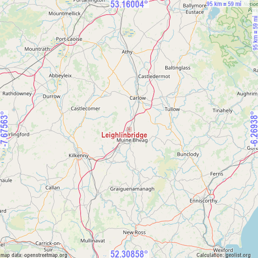
Leighlinbridge GPS coordinates[2]
52° 44' 11.004" North, 6° 58' 21" West
| Map corner | latitude | longitude |
|---|---|---|
| Upper-left | 53.16004°, | -7.67563° |
| Center: | 52.73639°, | -6.9725° |
| Lower-right: | 52.30858°, | -6.26938° |
| Map W x H: | 94.7×94.7 km | = 58.8×58.8mi |
| max Lat: | 55.25° ⇑70% North |
| Leighlinbridge: | 52.73639° |
| min Lat: | ⇓30% South 51.52487° |
| min Long | Leighlinbridge | max Long |
| -10.26889° | -6.9725° | -6.04944° |
| W 59.6%⇐ | ⇒40.4% E |
Elevation
Elevation of Leighlinbridge is 50 m = 164 ft, and this is 4.5 m = 15 ft below average elevation for this country.
| Max E: |
262 m = 860 ft | 50.7% |
| Avg. | 54.5 m = 179 ft | |
| Leighlinbridge | 50 m = 164 ft | |
Min E: |
0 m = 0 ft | 49.3% |
See also: Ireland elevation on elevation.city.
Geographical zone
Leighlinbridge is located in North temperate zone (between Tropic of Cancer and the Arctic Circle). Distance of this North polar circle is 1537.4 km =955.3 mi to North.| Distance of | km | miles | from Leighlinbridge |
|---|---|---|---|
| North Pole | 4143.3 | 2574.5 | to North |
| Arctic Circle | 1537.4 | 955.3 | to North |
| Tropic Cancer | 3257.8 | 2024.3 | to South |
| Equator | 5863.7 | 3643.5 | to South |


Nearby cities:
15 places around Leighlinbridge: (largest is in red/bold)
• Bagenalstown
4.1 km =2.5 mi,  169°
169°
• Ballon
13.8 km =8.6 mi,  88°
88°
• Ballylinan
23.6 km =14.7 mi,  348°
348°
• Bennettsbridge
21.3 km =13.2 mi,  221°
221°
• Borris
15.6 km =9.7 mi, 166°
• Bunclody
23.3 km =14.5 mi,  112°
112°
• Carlow
12 km =7.5 mi,  15°
15°
• Castlecomer
17.8 km =11.1 mi,  295°
295°
• Castledermot
21.1 km =13.1 mi, 24°
• Gowran
13.7 km =8.5 mi,  209°
209°
• Graiguenamanagh
21.8 km =13.5 mi,  176°
176°
• Kilkenny
20.9 km =13 mi,  244°
244°
• Moneenroe
16.9 km =10.5 mi,  313°
313°
• Paulstown
7 km =4.3 mi, 208°
• Tullow
17.4 km =10.8 mi,  65°
65°
Sources, notices
• [Note1] Compared only with cities in Ireland existing in our database
• [Src1] Map data: © OpenStreetMap contributors (CC-BY-SA)
• [Src2] Other city data from geonames.org with taken over terms of usage.
• [Src3] Geographical zone / Annual Mean Temperature by Robert A. Rohde @ Wikipedia
