Graiguenamanagh geodata
Graiguenamanagh (Leinster) is a populated place; located in Ireland in Europe/Dublin (GMT+1) time zone. With population of 1,543 people, there are 269 cities with bigger population in this country. Compared to other cities in Ireland, 78.4% of cities are located further ↑North; 60.9% of cities are located further ←West and 84.4% of cities have higher elevation than Graiguenamanagh. Note1


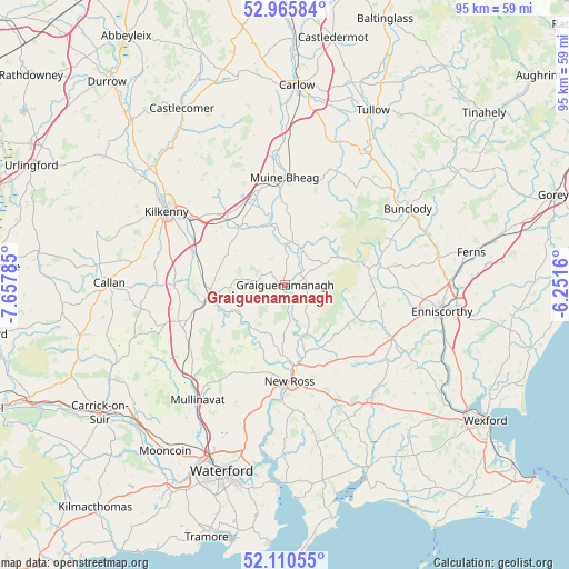
Graiguenamanagh GPS coordinates[2]
52° 32' 25.008" North, 6° 57' 16.992" West
| Map corner | latitude | longitude |
|---|---|---|
| Upper-left | 52.96584°, | -7.65785° |
| Center: | 52.54028°, | -6.95472° |
| Lower-right: | 52.11055°, | -6.2516° |
| Map W x H: | 95.1×95.1 km | = 59.1×59.1mi |
| max Lat: | 55.25° ⇑78.4% North |
| Graiguenamanagh: | 52.54028° |
| min Lat: | ⇓21.6% South 51.52487° |
| min Long | Graiguenamanagh | max Long |
| -10.26889° | -6.95472° | -6.04944° |
| W 60.9%⇐ | ⇒39.1% E |
Elevation
Elevation of Graiguenamanagh is 13 m = 43 ft, and this is 41.5 m = 136 ft below average elevation for this country.
| Max E: |
262 m = 860 ft | 84.4% |
| Avg. | 54.5 m = 179 ft | |
| Graiguenamanagh | 13 m = 43 ft | |
Min E: |
0 m = 0 ft | 15.6% |
See also: Ireland elevation on elevation.city.
Geographical zone
Graiguenamanagh is located in North temperate zone (between Tropic of Cancer and the Arctic Circle). Distance of this North polar circle is 1559.2 km =968.8 mi to North.| Distance of | km | miles | from Graiguenamanagh |
|---|---|---|---|
| North Pole | 4165.1 | 2588.1 | to North |
| Arctic Circle | 1559.2 | 968.8 | to North |
| Tropic Cancer | 3236 | 2010.8 | to South |
| Equator | 5841.9 | 3630 | to South |


Nearby cities:
15 places around Graiguenamanagh: (largest is in red/bold)
• Bagenalstown
17.8 km =11.1 mi,  358°
358°
• Ballon
25.6 km =15.9 mi,  29°
29°
• Bennettsbridge
16.3 km =10.1 mi,  290°
290°
• Borris
7.1 km =4.4 mi,  20°
20°
• Bunclody
24 km =14.9 mi,  57°
57°
• Callan
29.5 km =18.3 mi,  271°
271°
• Enniscorthy
27.2 km =16.9 mi,  99°
99°
• Ferns
31.2 km =19.4 mi,  80°
80°
• Gowran
12.7 km =7.9 mi,  321°
321°
• Kilkenny
23.8 km =14.8 mi,  302°
302°
• Kilmacow
29 km =18 mi,  211°
211°
• Leighlinbridge
21.8 km =13.5 mi, 356°
• New Ross
16 km =9.9 mi,  175°
175°
• Paulstown
16.3 km =10.1 mi,  343°
343°
• Thomastown
12.4 km =7.7 mi,  263°
263°
Sources, notices
• [Note1] Compared only with cities in Ireland existing in our database
• [Src1] Map data: © OpenStreetMap contributors (CC-BY-SA)
• [Src2] Other city data from geonames.org with taken over terms of usage.
• [Src3] Geographical zone / Annual Mean Temperature by Robert A. Rohde @ Wikipedia
