Kinsale geodata
Kinsale (Munster) is a populated place; located in Ireland in Europe/Dublin (GMT+1) time zone. With population of 3,843 people, there are 164 cities with bigger population in this country. Compared to other cities in Ireland, 98.5% of cities are located further ↑North; 76.1% of cities are located further →East and 53.9% of cities have higher elevation than Kinsale. Note1


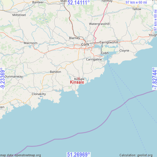
Kinsale GPS coordinates[2]
51° 42' 27" North, 8° 31' 50.016" West
| Map corner | latitude | longitude |
|---|---|---|
| Upper-left | 52.14111°, | -9.23369° |
| Center: | 51.7075°, | -8.53056° |
| Lower-right: | 51.26969°, | -7.82744° |
| Map W x H: | 96.9×96.9 km | = 60.2×60.2mi |
| max Lat: | 55.25° ⇑98.5% North |
| Kinsale: | 51.7075° |
| min Lat: | ⇓1.5% South 51.52487° |
| min Long | Kinsale | max Long |
| -10.26889° | -8.53056° | -6.04944° |
| W 23.9%⇐ | ⇒76.1% E |
Elevation
Elevation of Kinsale is 45 m = 148 ft, and this is 9.5 m = 31 ft below average elevation for this country.
| Max E: |
262 m = 860 ft | 53.9% |
| Avg. | 54.5 m = 179 ft | |
| Kinsale | 45 m = 148 ft | |
Min E: |
0 m = 0 ft | 46.1% |
See also: Ireland elevation on elevation.city.
Geographical zone
Kinsale is located in North temperate zone (between Tropic of Cancer and the Arctic Circle). Distance of this North polar circle is 1651.8 km =1026.4 mi to North.| Distance of | km | miles | from Kinsale |
|---|---|---|---|
| North Pole | 4257.7 | 2645.6 | to North |
| Arctic Circle | 1651.8 | 1026.4 | to North |
| Tropic Cancer | 3143.4 | 1953.2 | to South |
| Equator | 5749.3 | 3572.4 | to South |


Nearby cities:
15 places around Kinsale: (largest is in red/bold)
• Ballygarvan
13.6 km =8.5 mi,  20°
20°
• Bandon
15.2 km =9.4 mi,  286°
286°
• Belgooly
4.5 km =2.8 mi,  38°
38°
• Carrigaline
14.7 km =9.1 mi, 38°
• Cobh
22.7 km =14.1 mi,  45°
45°
• Cork
21.6 km =13.4 mi,  11°
11°
• Courtmacsherry
14.6 km =9.1 mi,  235°
235°
• Crosshaven
18.8 km =11.7 mi,  57°
57°
• Fountainstown
17.9 km =11.1 mi, 61°
• Innishannon
10.8 km =6.7 mi,  306°
306°
• Killumney
20 km =12.4 mi,  336°
336°
• Passage West
22.5 km =14 mi,  34°
34°
• Rathard
21.2 km =13.2 mi,  317°
317°
• Riverstick
7.6 km =4.7 mi, 19°
• Whitegate
24.8 km =15.4 mi, 56°
Sources, notices
• [Note1] Compared only with cities in Ireland existing in our database
• [Src1] Map data: © OpenStreetMap contributors (CC-BY-SA)
• [Src2] Other city data from geonames.org with taken over terms of usage.
• [Src3] Geographical zone / Annual Mean Temperature by Robert A. Rohde @ Wikipedia
