Qalansuwa geodata
Qalansuwa (Central District) is a populated place; located in Israel in Asia/Jerusalem (GMT+3) time zone. With population of 16,898 people, there are 75 cities with bigger population in this country. Compared to other cities in Israel, 51.5% of cities are located further ↓South; 60.4% of cities are located further →East and 81.1% of cities have higher elevation than Qalansuwa. Note1


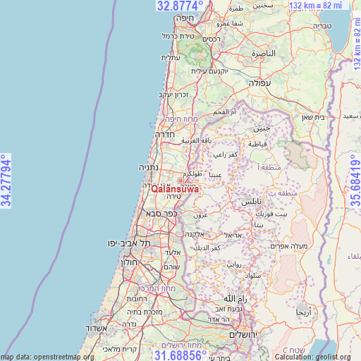
Qalansuwa GPS coordinates[2]
32° 17' 5.748" North, 34° 58' 51.816" East
| Map corner | latitude | longitude |
|---|---|---|
| Upper-left | 32.8774°, | 34.27794° |
| Center: | 32.28493°, | 34.98106° |
| Lower-right: | 31.68856°, | 35.68419° |
| Map W x H: | 132.2×132.2 km | = 82.1×82.1mi |
| max Lat: | 33.27918° ⇑48.5% North |
| Qalansuwa: | 32.28493° |
| min Lat: | ⇓51.5% South 29.55805° |
| min Long | Qalansuwa | max Long |
| 34.57149° | 34.98106° | 35.81084° |
| W 39.6%⇐ | ⇒60.4% E |
Elevation
Elevation of Qalansuwa is 39 m = 128 ft, and this is 184.4 m = 605 ft below average elevation for this country.
| Max E: |
988 m = 3241 ft | 81.1% |
| Avg. | 223.4 m = 733 ft | |
| Qalansuwa | 39 m = 128 ft | |
Min E: |
-380 m = -1247 ft | 18.9% |
See also: Israel elevation on elevation.city.
Geographical zone
Qalansuwa is located in North temperate zone (between Tropic of Cancer and the Arctic Circle). Distance of this Northern Tropic circle is 983.8 km =611.3 mi to South.| Distance of | km | miles | from Qalansuwa |
|---|---|---|---|
| North Pole | 6417.3 | 3987.5 | to North |
| Arctic Circle | 3811.4 | 2368.3 | to North |
| Tropic Cancer | 983.8 | 611.3 | to South |
| Equator | 3589.7 | 2230.5 | to South |


Nearby cities:
15 places around Qalansuwa: (largest is in red/bold)
• Bet Yiẕẖaq
9.9 km =6.2 mi,  298°
298°
• Elyakhin
14.7 km =9.1 mi,  338°
338°
• Even Yehuda
9 km =5.6 mi,  259°
259°
• Eṭ Ṭaiyiba
3.3 km =2.1 mi,  128°
128°
• Jaljūlya
14.7 km =9.1 mi,  190°
190°
• Kefar Yona
5.6 km =3.5 mi,  309°
309°
• Kfar Saba
14.1 km =8.8 mi,  209°
209°
• Netanya
12.6 km =7.8 mi, 295°
• Nirit
15.4 km =9.6 mi,  178°
178°
• Nordiyya
8.6 km =5.3 mi,  292°
292°
• Pardesiyya
7.1 km =4.4 mi, 288°
• Ra'anana
15.1 km =9.4 mi,  221°
221°
• Tel Mond
7.1 km =4.4 mi,  236°
236°
• Tirah
6.4 km =4 mi, 207°
• Ẕur Moshe
6.6 km =4.1 mi,  283°
283°
Sources, notices
• [Note1] Compared only with cities in Israel existing in our database
• [Src1] Map data: © OpenStreetMap contributors (CC-BY-SA)
• [Src2] Other city data from geonames.org with taken over terms of usage.
• [Src3] Geographical zone / Annual Mean Temperature by Robert A. Rohde @ Wikipedia
