Sallama geodata
Sallama (Northern District) is a populated place; located in Israel in Asia/Jerusalem (GMT+3) time zone. With population of 1,800 people, there are 142 cities with bigger population in this country. Compared to other cities in Israel, 84.6% of cities are located further ↓South; 87.6% of cities are located further ←West and 56.8% of cities have lower elevation than Sallama. Note1


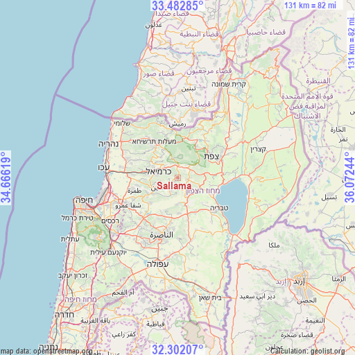
Sallama GPS coordinates[2]
32° 53' 39.948" North, 35° 22' 9.516" East
| Map corner | latitude | longitude |
|---|---|---|
| Upper-left | 33.48285°, | 34.66619° |
| Center: | 32.89443°, | 35.36931° |
| Lower-right: | 32.30207°, | 36.07244° |
| Map W x H: | 131.3×131.3 km | = 81.6×81.6mi |
| max Lat: | 33.27918° ⇑15.4% North |
| Sallama: | 32.89443° |
| min Lat: | ⇓84.6% South 29.55805° |
| min Long | Sallama | max Long |
| 34.57149° | 35.36931° | 35.81084° |
| W 87.6%⇐ | ⇒12.4% E |
Elevation
Elevation of Sallama is 172 m = 564 ft, and this is 51.4 m = 169 ft below average elevation for this country.
| Max E: |
988 m = 3241 ft | 43.2% |
| Avg. | 223.4 m = 733 ft | |
| Sallama | 172 m = 564 ft | |
Min E: |
-380 m = -1247 ft | 56.8% |
See also: Israel elevation on elevation.city.
Geographical zone
Sallama is located in North temperate zone (between Tropic of Cancer and the Arctic Circle). Distance of this Northern Tropic circle is 1051.6 km =653.4 mi to South.| Distance of | km | miles | from Sallama |
|---|---|---|---|
| North Pole | 6349.5 | 3945.4 | to North |
| Arctic Circle | 3743.7 | 2326.2 | to North |
| Tropic Cancer | 1051.6 | 653.4 | to South |
| Equator | 3657.5 | 2272.7 | to South |


Nearby cities:
15 places around Sallama: (largest is in red/bold)
• Beit Jann
7.9 km =4.9 mi,  8°
8°
• Buqei‘a
9.8 km =6.1 mi,  340°
340°
• Bu‘eina
9.8 km =6.1 mi,  182°
182°
• Deir Ḥannā
3.6 km =2.2 mi,  188°
188°
• Kafr Mandā
13.8 km =8.6 mi,  227°
227°
• Karmi’el
6.5 km =4 mi,  292°
292°
• Kaukab Abū el Hījā
13.3 km =8.3 mi,  238°
238°
• Kefar Weradim
14 km =8.7 mi,  322°
322°
• Maghār
3.6 km =2.2 mi,  98°
98°
• Naḥf
6.6 km =4.1 mi,  312°
312°
• Sakhnīn
7.5 km =4.7 mi, 243°
• Sājūr
6 km =3.7 mi,  334°
334°
• Ḥurfeish
13.8 km =8.6 mi,  351°
351°
• ‘Eilabun
7 km =4.3 mi,  155°
155°
• ‘Uzeir
12 km =7.5 mi,  197°
197°
Sources, notices
• [Note1] Compared only with cities in Israel existing in our database
• [Src1] Map data: © OpenStreetMap contributors (CC-BY-SA)
• [Src2] Other city data from geonames.org with taken over terms of usage.
• [Src3] Geographical zone / Annual Mean Temperature by Robert A. Rohde @ Wikipedia
