‘Eilabun geodata
‘Eilabun (Northern District) is a populated place; located in Israel in Asia/Jerusalem (GMT+3) time zone. With population of 4,400 people, there are 116 cities with bigger population in this country. Compared to other cities in Israel, 79.9% of cities are located further ↓South; 90.5% of cities are located further ←West and 58.6% of cities have lower elevation than ‘Eilabun. Note1


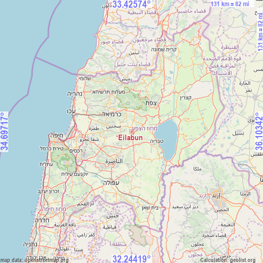
‘Eilabun GPS coordinates[2]
32° 50' 12.948" North, 35° 24' 1.044" East
| Map corner | latitude | longitude |
|---|---|---|
| Upper-left | 33.42574°, | 34.69717° |
| Center: | 32.83693°, | 35.40029° |
| Lower-right: | 32.24419°, | 36.10342° |
| Map W x H: | 131.4×131.4 km | = 81.6×81.6mi |
| max Lat: | 33.27918° ⇑20.1% North |
| ‘Eilabun: | 32.83693° |
| min Lat: | ⇓79.9% South 29.55805° |
| min Long | ‘Eilabun | max Long |
| 34.57149° | 35.40029° | 35.81084° |
| W 90.5%⇐ | ⇒9.5% E |
Elevation
Elevation of ‘Eilabun is 187 m = 614 ft, and this is 36.4 m = 119 ft below average elevation for this country.
| Max E: |
988 m = 3241 ft | 41.4% |
| Avg. | 223.4 m = 733 ft | |
| ‘Eilabun | 187 m = 614 ft | |
Min E: |
-380 m = -1247 ft | 58.6% |
See also: Israel elevation on elevation.city.
Geographical zone
‘Eilabun is located in North temperate zone (between Tropic of Cancer and the Arctic Circle). Distance of this Northern Tropic circle is 1045.2 km =649.5 mi to South.| Distance of | km | miles | from ‘Eilabun |
|---|---|---|---|
| North Pole | 6355.9 | 3949.4 | to North |
| Arctic Circle | 3750 | 2330.1 | to North |
| Tropic Cancer | 1045.2 | 649.5 | to South |
| Equator | 3651.1 | 2268.7 | to South |


Nearby cities:
15 places around ‘Eilabun: (largest is in red/bold)
• Bu‘eina
4.7 km =2.9 mi,  224°
224°
• Deir Ḥannā
4.4 km =2.7 mi,  309°
309°
• Kafr Kammā
13.4 km =8.3 mi,  163°
163°
• Kafr Kannā
11.4 km =7.1 mi,  208°
208°
• Kafr Mandā
13.4 km =8.3 mi,  257°
257°
• Karmi’el
12.6 km =7.8 mi,  315°
315°
• Kaukab Abū el Hījā
14.2 km =8.8 mi,  267°
267°
• Maghār
5.9 km =3.7 mi,  6°
6°
• Naḥf
13.4 km =8.3 mi, 324°
• Rumat Heib
11 km =6.8 mi,  233°
233°
• Sakhnīn
10.1 km =6.3 mi,  287°
287°
• Sallama
7 km =4.3 mi,  335°
335°
• Sājūr
13 km =8.1 mi,  334°
334°
• Tiberias
13.2 km =8.2 mi,  112°
112°
• ‘Uzeir
8.3 km =5.2 mi, 232°
Sources, notices
• [Note1] Compared only with cities in Israel existing in our database
• [Src1] Map data: © OpenStreetMap contributors (CC-BY-SA)
• [Src2] Other city data from geonames.org with taken over terms of usage.
• [Src3] Geographical zone / Annual Mean Temperature by Robert A. Rohde @ Wikipedia
