Ḥurfeish geodata
Ḥurfeish (Northern District) is a populated place; located in Israel in Asia/Jerusalem (GMT+3) time zone. With population of 5,308 people, there are 107 cities with bigger population in this country. Compared to other cities in Israel, 95.3% of cities are located further ↓South; 84.6% of cities are located further ←West and 91.1% of cities have lower elevation than Ḥurfeish. Note1


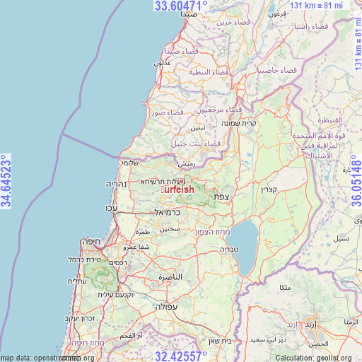
Ḥurfeish GPS coordinates[2]
33° 1' 1.596" North, 35° 20' 54.06" East
| Map corner | latitude | longitude |
|---|---|---|
| Upper-left | 33.60471°, | 34.64523° |
| Center: | 33.01711°, | 35.34835° |
| Lower-right: | 32.42557°, | 36.05148° |
| Map W x H: | 131.1×131.1 km | = 81.5×81.5mi |
| max Lat: | 33.27918° ⇑4.7% North |
| Ḥurfeish: | 33.01711° |
| min Lat: | ⇓95.3% South 29.55805° |
| min Long | Ḥurfeish | max Long |
| 34.57149° | 35.34835° | 35.81084° |
| W 84.6%⇐ | ⇒15.4% E |
Elevation
Elevation of Ḥurfeish is 657 m = 2156 ft, and this is 433.6 m = 1423 ft above average elevation for this country.
| Max E: |
988 m = 3241 ft | 8.9% |
| Ḥurfeish | 657 m 2156 ft | |
| Avg. | 223.4 m = 733 ft | |
Min E: |
-380 m = -1247 ft | 91.1% |
See also: Israel elevation on elevation.city.
Geographical zone
Ḥurfeish is located in North temperate zone (between Tropic of Cancer and the Arctic Circle). Distance of this Northern Tropic circle is 1065.2 km =661.9 mi to South.| Distance of | km | miles | from Ḥurfeish |
|---|---|---|---|
| North Pole | 6335.9 | 3936.9 | to North |
| Arctic Circle | 3730 | 2317.7 | to North |
| Tropic Cancer | 1065.2 | 661.9 | to South |
| Equator | 3671.2 | 2281.2 | to South |


Nearby cities:
15 places around Ḥurfeish: (largest is in red/bold)
• Beit Jann
6.6 km =4.1 mi,  152°
152°
• Buqei‘a
4.6 km =2.9 mi,  197°
197°
• Deir Ḥannā
17.3 km =10.7 mi,  175°
175°
• Jīsh
9.2 km =5.7 mi,  86°
86°
• Karmi’el
11.8 km =7.3 mi, 199°
• Kefar Weradim
7.1 km =4.4 mi,  248°
248°
• Maghār
15.2 km =9.4 mi,  158°
158°
• Mi‘ilyā
8.6 km =5.3 mi,  277°
277°
• Naḥf
9.7 km =6 mi, 197°
• Pasuta
5.1 km =3.2 mi,  313°
313°
• Safed
15 km =9.3 mi,  112°
112°
• Sakhnīn
17.7 km =11 mi, 195°
• Sallama
13.8 km =8.6 mi,  171°
171°
• Sājūr
8.3 km =5.2 mi, 184°
• maalot Tarshīhā
7.6 km =4.7 mi,  269°
269°
Sources, notices
• [Note1] Compared only with cities in Israel existing in our database
• [Src1] Map data: © OpenStreetMap contributors (CC-BY-SA)
• [Src2] Other city data from geonames.org with taken over terms of usage.
• [Src3] Geographical zone / Annual Mean Temperature by Robert A. Rohde @ Wikipedia
