Maghār geodata
Maghār (Northern District) is a populated place; located in Israel in Asia/Jerusalem (GMT+3) time zone. With population of 18,915 people, there are 69 cities with bigger population in this country. Compared to other cities in Israel, 84% of cities are located further ↓South; 91.1% of cities are located further ←West and 72.2% of cities have lower elevation than Maghār. Note1


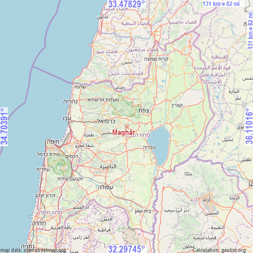
Maghār GPS coordinates[2]
32° 53' 23.424" North, 35° 24' 25.308" East
| Map corner | latitude | longitude |
|---|---|---|
| Upper-left | 33.47829°, | 34.70391° |
| Center: | 32.88984°, | 35.40703° |
| Lower-right: | 32.29745°, | 36.11016° |
| Map W x H: | 131.3×131.3 km | = 81.6×81.6mi |
| max Lat: | 33.27918° ⇑16% North |
| Maghār: | 32.88984° |
| min Lat: | ⇓84% South 29.55805° |
| min Long | Maghār | max Long |
| 34.57149° | 35.40703° | 35.81084° |
| W 91.1%⇐ | ⇒8.9% E |
Elevation
Elevation of Maghār is 292 m = 958 ft, and this is 68.6 m = 225 ft above average elevation for this country.
| Max E: |
988 m = 3241 ft | 27.8% |
| Maghār | 292 m 958 ft | |
| Avg. | 223.4 m = 733 ft | |
Min E: |
-380 m = -1247 ft | 72.2% |
See also: Israel elevation on elevation.city.
Geographical zone
Maghār is located in North temperate zone (between Tropic of Cancer and the Arctic Circle). Distance of this Northern Tropic circle is 1051.1 km =653.1 mi to South.| Distance of | km | miles | from Maghār |
|---|---|---|---|
| North Pole | 6350.1 | 3945.8 | to North |
| Arctic Circle | 3744.2 | 2326.5 | to North |
| Tropic Cancer | 1051.1 | 653.1 | to South |
| Equator | 3657 | 2272.4 | to South |


Nearby cities:
15 places around Maghār: (largest is in red/bold)
• Beit Jann
8.7 km =5.4 mi,  344°
344°
• Buqei‘a
11.9 km =7.4 mi,  324°
324°
• Bu‘eina
10.1 km =6.3 mi,  202°
202°
• Deir Ḥannā
5.1 km =3.2 mi,  232°
232°
• Jīsh
15.2 km =9.4 mi,  14°
14°
• Karmi’el
10 km =6.2 mi,  287°
287°
• Naḥf
9.8 km =6.1 mi,  300°
300°
• Rosh Pinna
15.4 km =9.6 mi,  55°
55°
• Safed
11.8 km =7.3 mi,  44°
44°
• Sakhnīn
10.7 km =6.6 mi,  254°
254°
• Sallama
3.6 km =2.2 mi,  278°
278°
• Sājūr
8.5 km =5.3 mi,  313°
313°
• Ḥurfeish
15.2 km =9.4 mi, 338°
• ‘Eilabun
5.9 km =3.7 mi,  186°
186°
• ‘Uzeir
13 km =8.1 mi,  213°
213°
Sources, notices
• [Note1] Compared only with cities in Israel existing in our database
• [Src1] Map data: © OpenStreetMap contributors (CC-BY-SA)
• [Src2] Other city data from geonames.org with taken over terms of usage.
• [Src3] Geographical zone / Annual Mean Temperature by Robert A. Rohde @ Wikipedia
