Shivaji Nagar geodata
Shivaji Nagar (Maharashtra) is a section of populated place; located in India in Asia/Kolkata (GMT+5.5) time zone. With population of 1,000,000 people, there are 41 cities with bigger population in this country. Compared to other cities in India, 70.3% of cities are located further ↑North; 90.7% of cities are located further →East and 85.7% of cities have lower elevation than Shivaji Nagar. Note1


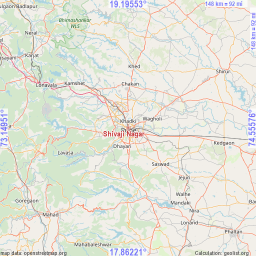
Shivaji Nagar GPS coordinates[2]
18° 31' 48.612" North, 73° 51' 9.468" East
| Map corner | latitude | longitude |
|---|---|---|
| Upper-left | 19.19553°, | 73.14951° |
| Center: | 18.53017°, | 73.85263° |
| Lower-right: | 17.86221°, | 74.55576° |
| Map W x H: | 148.3×148.3 km | = 92.1×92.1mi |
| max Lat: | 34.9274° ⇑70.3% North |
| Shivaji Nagar: | 18.53017° |
| min Lat: | ⇓29.7% South 8.09008° |
| min Long | Shivaji Nagar | max Long |
| 68.82655° | 73.85263° | 96.81° |
| W 9.3%⇐ | ⇒90.7% E |
Elevation
Elevation of Shivaji Nagar is 559 m = 1834 ft, and this is 263.4 m = 864 ft above average elevation for this country.
| Max E: |
3681 m = 12077 ft | 14.3% |
| Shivaji Nagar | 559 m 1834 ft | |
| Avg. | 295.6 m = 970 ft | |
Min E: |
1 m = 3 ft | 85.7% |
See also: Shivaji Nagar elevation on elevation.city.
Geographical zone
Shivaji Nagar is located in North Torrid zone (between Equator and Tropic of Cancer). Distance of this Northern Tropic circle is 545.6 km =339 mi to North.| Distance of | km | miles | from Shivaji Nagar |
|---|---|---|---|
| North Pole | 7946.7 | 4937.8 | to North |
| Arctic Circle | 5340.8 | 3318.6 | to North |
| Tropic Cancer | 545.6 | 339 | to North |
| Equator | 2060.4 | 1280.3 | to South |


Nearby cities:
15 places around Shivaji Nagar: (largest is in red/bold)
• Alandi
17.1 km =10.6 mi,  16°
16°
• Bhor
42.4 km =26.3 mi,  181°
181°
• Chākan
25.6 km =15.9 mi,  2°
2°
• Dehu
22.8 km =14.2 mi,  336°
336°
• Khadki
3.7 km =2.3 mi,  359°
359°
• Kharakvasla
12.9 km =8 mi,  219°
219°
• Khed
21.4 km =13.3 mi, 181°
• Koregaon
25.3 km =15.7 mi,  59°
59°
• Lohogaon
11 km =6.8 mi,  45°
45°
• Pimpri
11.4 km =7.1 mi,  334°
334°
• Pune
1.2 km =0.7 mi,  166°
166°
• Rājgurunagar
37.7 km =23.4 mi,  7°
7°
• Sāsvad
28 km =17.4 mi,  137°
137°
• Talegaon Dābhāde
29.4 km =18.3 mi,  320°
320°
• Wadgaon
32.3 km =20.1 mi, 315°
Sources, notices
• [Note1] Compared only with cities in India existing in our database
• [Src1] Map data: © OpenStreetMap contributors (CC-BY-SA)
• [Src2] Other city data from geonames.org with taken over terms of usage.
• [Src3] Geographical zone / Annual Mean Temperature by Robert A. Rohde @ Wikipedia
