Koregaon geodata
Koregaon (Maharashtra) is a populated place; located in India in Asia/Kolkata (GMT+5.5) time zone. With population of 25,846 people, there are 1646 cities with bigger population in this country. Compared to other cities in India, 69.9% of cities are located further ↑North; 88.9% of cities are located further →East and 85.2% of cities have lower elevation than Koregaon. Note1


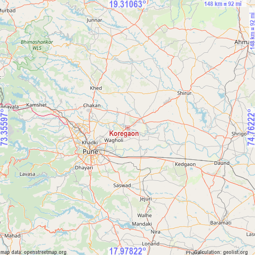
Koregaon GPS coordinates[2]
18° 38' 44.628" North, 74° 3' 32.724" East
| Map corner | latitude | longitude |
|---|---|---|
| Upper-left | 19.31063°, | 73.35597° |
| Center: | 18.64573°, | 74.05909° |
| Lower-right: | 17.97822°, | 74.76222° |
| Map W x H: | 148.2×148.2 km | = 92.1×92.1mi |
| max Lat: | 34.9274° ⇑69.9% North |
| Koregaon: | 18.64573° |
| min Lat: | ⇓30.1% South 8.09008° |
| min Long | Koregaon | max Long |
| 68.82655° | 74.05909° | 96.81° |
| W 11.1%⇐ | ⇒88.9% E |
Elevation
Elevation of Koregaon is 552 m = 1811 ft, and this is 256.4 m = 841 ft above average elevation for this country.
| Max E: |
3681 m = 12077 ft | 14.8% |
| Koregaon | 552 m 1811 ft | |
| Avg. | 295.6 m = 970 ft | |
Min E: |
1 m = 3 ft | 85.2% |
See also: India elevation on elevation.city.
Geographical zone
Koregaon is located in North Torrid zone (between Equator and Tropic of Cancer). Distance of this Northern Tropic circle is 532.7 km =331 mi to North.| Distance of | km | miles | from Koregaon |
|---|---|---|---|
| North Pole | 7933.9 | 4929.9 | to North |
| Arctic Circle | 5328 | 3310.7 | to North |
| Tropic Cancer | 532.7 | 331 | to North |
| Equator | 2073.2 | 1288.2 | to South |


Nearby cities:
15 places around Koregaon: (largest is in red/bold)
• Alandi
17.3 km =10.7 mi,  281°
281°
• Chākan
24.2 km =15 mi,  301°
301°
• Dehu
31.9 km =19.8 mi, 284°
• Khadki
23.7 km =14.7 mi,  247°
247°
• Kharakvasla
37.6 km =23.4 mi,  232°
232°
• Khed
40.9 km =25.4 mi,  213°
213°
• Lohogaon
14.8 km =9.2 mi, 249°
• Manchar
41.7 km =25.9 mi,  343°
343°
• Pimpri
26.7 km =16.6 mi,  264°
264°
• Pune
25.6 km =15.9 mi,  236°
236°
• Rājgurunagar
29.7 km =18.5 mi,  325°
325°
• Shivaji Nagar
25.3 km =15.7 mi, 239°
• Sirūr
38.9 km =24.2 mi,  58°
58°
• Sāsvad
33.7 km =20.9 mi,  185°
185°
• Talegaon Dābhāde
41.6 km =25.8 mi, 283°
Sources, notices
• [Note1] Compared only with cities in India existing in our database
• [Src1] Map data: © OpenStreetMap contributors (CC-BY-SA)
• [Src2] Other city data from geonames.org with taken over terms of usage.
• [Src3] Geographical zone / Annual Mean Temperature by Robert A. Rohde @ Wikipedia
