Lohogaon geodata
Lohogaon (Maharashtra) is a populated place; located in India in Asia/Kolkata (GMT+5.5) time zone. With population of 13,529 people, there are 2611 cities with bigger population in this country. Compared to other cities in India, 70.1% of cities are located further ↑North; 90.1% of cities are located further →East and 88.3% of cities have lower elevation than Lohogaon. Note1


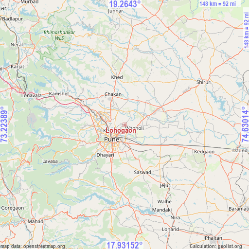
Lohogaon GPS coordinates[2]
18° 35' 57.156" North, 73° 55' 37.236" East
| Map corner | latitude | longitude |
|---|---|---|
| Upper-left | 19.2643°, | 73.22389° |
| Center: | 18.59921°, | 73.92701° |
| Lower-right: | 17.93152°, | 74.63014° |
| Map W x H: | 148.2×148.2 km | = 92.1×92.1mi |
| max Lat: | 34.9274° ⇑70.1% North |
| Lohogaon: | 18.59921° |
| min Lat: | ⇓29.9% South 8.09008° |
| min Long | Lohogaon | max Long |
| 68.82655° | 73.92701° | 96.81° |
| W 9.9%⇐ | ⇒90.1% E |
Elevation
Elevation of Lohogaon is 597 m = 1959 ft, and this is 301.4 m = 989 ft above average elevation for this country.
| Max E: |
3681 m = 12077 ft | 11.7% |
| Lohogaon | 597 m 1959 ft | |
| Avg. | 295.6 m = 970 ft | |
Min E: |
1 m = 3 ft | 88.3% |
See also: India elevation on elevation.city.
Geographical zone
Lohogaon is located in North Torrid zone (between Equator and Tropic of Cancer). Distance of this Northern Tropic circle is 537.9 km =334.2 mi to North.| Distance of | km | miles | from Lohogaon |
|---|---|---|---|
| North Pole | 7939 | 4933.1 | to North |
| Arctic Circle | 5333.1 | 3313.8 | to North |
| Tropic Cancer | 537.9 | 334.2 | to North |
| Equator | 2068 | 1285 | to South |


Nearby cities:
15 places around Lohogaon: (largest is in red/bold)
• Alandi
9.2 km =5.7 mi,  341°
341°
• Chākan
19.1 km =11.9 mi, 339°
• Dehu
21.5 km =13.4 mi,  308°
308°
• Jejūri
43.5 km =27 mi,  145°
145°
• Khadki
8.8 km =5.5 mi,  243°
243°
• Kharakvasla
23.9 km =14.9 mi,  222°
222°
• Khed
30.2 km =18.8 mi,  196°
196°
• Koregaon
14.8 km =9.2 mi,  69°
69°
• Pimpri
12.9 km =8 mi,  281°
281°
• Pune
11.6 km =7.2 mi, 220°
• Rājgurunagar
29.9 km =18.6 mi,  354°
354°
• Shivaji Nagar
11 km =6.8 mi,  225°
225°
• Sāsvad
30.5 km =19 mi,  158°
158°
• Talegaon Dābhāde
30.5 km =19 mi,  299°
299°
• Wadgaon
34.1 km =21.2 mi, 297°
Sources, notices
• [Note1] Compared only with cities in India existing in our database
• [Src1] Map data: © OpenStreetMap contributors (CC-BY-SA)
• [Src2] Other city data from geonames.org with taken over terms of usage.
• [Src3] Geographical zone / Annual Mean Temperature by Robert A. Rohde @ Wikipedia
