Sāsvad geodata
Sāsvad (Maharashtra) is a populated place; located in India in Asia/Kolkata (GMT+5.5) time zone. With population of 29,858 people, there are 1451 cities with bigger population in this country. Compared to other cities in India, 70.9% of cities are located further ↑North; 89.1% of cities are located further →East and 93.4% of cities have lower elevation than Sāsvad. Note1


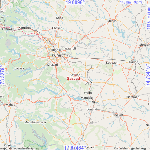
Sāsvad GPS coordinates[2]
18° 20' 36.636" North, 74° 1' 51.672" East
| Map corner | latitude | longitude |
|---|---|---|
| Upper-left | 19.0096°, | 73.3279° |
| Center: | 18.34351°, | 74.03102° |
| Lower-right: | 17.67484°, | 74.73415° |
| Map W x H: | 148.4×148.4 km | = 92.2×92.2mi |
| max Lat: | 34.9274° ⇑70.9% North |
| Sāsvad: | 18.34351° |
| min Lat: | ⇓29.1% South 8.09008° |
| min Long | Sāsvad | max Long |
| 68.82655° | 74.03102° | 96.81° |
| W 10.9%⇐ | ⇒89.1% E |
Elevation
Elevation of Sāsvad is 771 m = 2530 ft, and this is 475.4 m = 1560 ft above average elevation for this country.
| Max E: |
3681 m = 12077 ft | 6.6% |
| Sāsvad | 771 m 2530 ft | |
| Avg. | 295.6 m = 970 ft | |
Min E: |
1 m = 3 ft | 93.4% |
See also: India elevation on elevation.city.
Geographical zone
Sāsvad is located in North Torrid zone (between Equator and Tropic of Cancer). Distance of this Northern Tropic circle is 566.3 km =351.9 mi to North.| Distance of | km | miles | from Sāsvad |
|---|---|---|---|
| North Pole | 7967.5 | 4950.8 | to North |
| Arctic Circle | 5361.6 | 3331.5 | to North |
| Tropic Cancer | 566.3 | 351.9 | to North |
| Equator | 2039.6 | 1267.3 | to South |


Nearby cities:
15 places around Sāsvad: (largest is in red/bold)
• Alandi
39.7 km =24.7 mi,  339°
339°
• Bhor
29.4 km =18.3 mi,  222°
222°
• Chākan
49.6 km =30.8 mi, 339°
• Dehu
50.2 km =31.2 mi,  326°
326°
• Jejūri
15.5 km =9.6 mi,  118°
118°
• Khadki
30.9 km =19.2 mi,  322°
322°
• Kharakvasla
29 km =18 mi,  291°
291°
• Khed
19.5 km =12.1 mi,  268°
268°
• Koregaon
33.7 km =20.9 mi,  5°
5°
• Lohogaon
30.5 km =19 mi, 338°
• Pimpri
39 km =24.2 mi, 322°
• Pune
27 km =16.8 mi, 316°
• Shirwal
22.2 km =13.8 mi,  194°
194°
• Shivaji Nagar
28 km =17.4 mi, 317°
• Wai
45.9 km =28.5 mi,  198°
198°
Sources, notices
• [Note1] Compared only with cities in India existing in our database
• [Src1] Map data: © OpenStreetMap contributors (CC-BY-SA)
• [Src2] Other city data from geonames.org with taken over terms of usage.
• [Src3] Geographical zone / Annual Mean Temperature by Robert A. Rohde @ Wikipedia
